Strategic Objective 3.2
Enhance the conservation and management of coastal and marine resources to meet America’s economic, social, and environmental needs
The Department works to protect, restore, and manage ocean and coastal resources. To meet this mandate, the Department maintains a world-class expertise in oceanography, marine ecology, fisheries management, conservation biology, and risk assessment. To achieve balance among ecological, environmental, and social influences, the Department has adopted an ecosystem approach to management—an approach that is deliberate, incremental, and collaborative. Within the Department, NOAA’s mission “to protect, restore, and manage fisheries and coastal and ocean resources” is critical to the health of the U.S. economy. To the extent it is possible to balance sustainable economic development and healthy functioning marine ecosystems, the Department seeks to provide an example for the rest of the world in how to protect, restore, and manage resources of the world’s oceans and coasts. In addition, NOAA’s mission to support safe and efficient transportation systems is crucial to the U.S. economy. Department information improves transportation efficiency and safety on roads, rails, and waterways. The Department supports commerce through marine, aviation, and surface weather forecasts; the availability of accurate and advanced Electronic Navigational Charts (ENC); and the delivery of real-time oceanographic information. The Department provides consistent, accurate, and timely positioning information that is critical for air, sea, and surface transportation. The Department responds to hazardous material spills and provides search and rescue location support routinely to save lives and money and to protect the coastal environment. The Department works with port and coastal communities and with federal and state partners to ensure that port operations and development proceed efficiently and in an environmentally sound manner. The Department works with the Federal Aviation Administration (FAA) and the private sector to reduce the negative impacts of weather on aviation without compromising safety. Finally, the Department enforces regulations, reviews applications, and supports U.S. government interests in policy coordination on commercial remote sensing.
Performance Goal: Protect, restore, and manage the use of coastal and ocean resources through an ecosystem approach to management (NOAA)
|
||||||||||||||||||||||||||||||||||||||||||||||||||||||||||||||||||||||||||||||||||||||||||||||||||||||||||||||||||||||||||||||||||||||||||||||||||||||||||||||||||||||||||||||||||||
| Rating | Results |
|---|---|
| Exceeded Target | 2 |
| On Target | 6 |
| Slightly Below Target | 0 |
| Below Target | 0 |
| See Appendix A: Performance and Resource Tables for individual reported results. | |
Coastal areas are among the most developed in the nation, with over half the population living on less than one-fifth of the land in the contiguous United States. At over 230 persons per square mile, the population density of the near shore is three times that of the nation as a whole. That portion of the U.S. economy that depends directly on the ocean is also large, with 2.3 million people employed and over $117 billion in value added to the national economy in 2000. Approximately 89 million people vacation and recreate along U.S. coasts every year. The amount added annually to the national economy by the commercial and recreational fishing industry alone is over $43 billion with an additional $1 billion of marine and freshwater aquaculture sales. With its Exclusive Economic Zone of 3.4 million square miles, the United States manages the largest marine territory of any nation in the world. Within this context, NOAA works with its partners to achieve a balance between the use and protection of these resources to ensure their sustainability, health, and vitality for the benefit of this and future generations and their optimal contribution to the nation’s economy and society.
In FY 2006, NOAA provided national and international leadership for the U.S. Ocean Action Plan by participating in the development of the U.S. Ocean Research Priorities Plan and Implementation Strategy and by supporting the establishment of the coordinated Ocean Governance Structure. NOAA continued rebuilding fisheries and reducing capacity to improve food security, increase economic benefits, and improve stability of marine ecosystems. NOAA also promoted greater use of market-based systems for fisheries management and regional collaboration on Oceans, Coasts, and Great Lakes Policy in partnership with leadership of states, local, and tribal leadership.
Some highlights from FY 2006 include:
Top environmental officials from the five Gulf Coast states and 13 federal agencies unveiled a plan to strengthen environmental protection for the Gulf of Mexico and further the ongoing recovery and rebuilding effort after the devastating effects of the 2005 hurricane season. The Governors’ Action Plan for Healthy and Resilient Coasts is a framework and guide for meaningful and sustained progress in the shared stewardship of the Gulf of Mexico by the U.S. Gulf states.
|
The state-federal alliance outlined 11 actions to improve and protect water quality, restore coastal wetlands and estuarine ecosystems, reduce pollution and nutrient loading, identify Gulf habitats to support coastal management, and expand environmental education. They include:
Federal and state officials, along with local volunteers, teamed up to free a humpback whale from a life-threatening entanglement. Members of the National Marine Fisheries Service (NMFS) and Hawaiian Islands Humpback Whale National Marine Sanctuary, and Hawaii Department of Land and Natural Resources, along with the community-based Whale Disentanglement Network unraveled lines dragging 25 feet from the whale’s mouth and freed the humpback whale, which was located off the north side of the island of Lana’i. The whale was entangled in 5/8 inches and 3/4 inches diameter lines coming from the left side of its mouth. Two large red buoys and a smaller bullet buoy were part of the gear dragging from the whale, threatening the health of the animal.
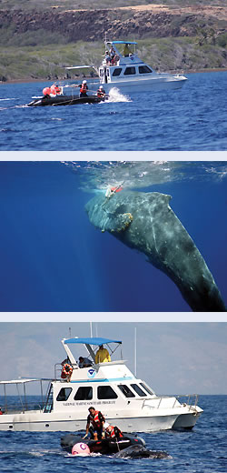 NOAA image of efforts to disentangle a humpback whale in Hawaiian waters. |
The Hawaiian Island Disentanglement Network has experienced and trained personnel that are authorized to safely cut large whales free of gear and marine debris using specially designed tools and techniques. The network in Hawaii is a partnership of federal, state and local members that also includes staff from NOAA Fisheries Pacific Islands Regional Office and the Marine Mammal Health and Stranding Response Program. The disentanglement network operates in other parts of the United States and its regional teams have successfully freed more than 50 large whales over the years along the east coast of the United States and Canada, the Caribbean, Alaska and in Hawaii without a single serious injury.
While cutting an animal free of a life threatening entanglement may save the animal, it is not the long-term answer to the problem. Preventing entanglements is actually the ultimate solution, and cutting whales free and documenting entanglements in the meantime provides valuable information to help us prevent entanglements in the future.
A new harmful algal bloom forecast system developed by NOAA is now in place along the Gulf Coast of Texas. The announcement of the ecological forecast program was made at the meeting of the Gulf of Mexico Alliance, a federal-state partnership to address critical coastal issues facing the Gulf states. The system generates forecasts weekly to determine the current and future location and intensity of blooms, and the likely impacts to the environment. “Because these blooms contain neurotoxins, they threaten human and ecosystem health, and can substantially impact coastal economies,” said Margaret A. Davidson, director of the NOAA Coastal Services Center and the NOAA delegate to the alliance. “Using a combination of satellite and in-place ocean and coastal observational data for ecological forecast systems shows the value and need for the development of an IOOS, one that can assist in addressing the threats to our health and our economy caused by harmful algal blooms.”
NOAA announced that it will expand regional coverage for the NOAA Coral Reef Watch Satellite Bleaching Alert monitoring system from six Caribbean sites to a total of 24 sites throughout the United States and international Caribbean. This is one of the Administration’s Ocean Action Plan initiatives that call for development of new international partnerships to enhance the management of coral reefs. The expansion was made possible through collaborative efforts with NOAA, the World Bank, and the Global Environment Facility.
The alert system is part of a growing number of in-place components of an integrated ocean observing system, which in turn is helping develop a coordinated ocean research plan and advancing international capacity building.
The warning system will give local officials advance warning that a bleaching event is about to occur. With this advance notice, officials can take measures to prevent human activity, such as diving, boating and recreational fishing, from adding to the stress of higher sea temperatures already affecting the coral reefs.
Coral bleaching is associated with a variety of stresses, including increased sea surface temperatures. This causes the coral to expel symbiotic micro-algae living in their tissues — algae that provide corals with food. Losing their algae leaves coral tissues devoid of color, and thus the coral appears to be bleached. Prolonged coral bleaching (more than a week) can lead to coral death and the subsequent loss of coral reef habitats for a range of marine life.
Advance warnings of the oncoming event were first reported in July 2005 by the NOAA Coral Reef Watch Satellite Bleaching Alert system; the first bleaching was seen in late August 2005 in the Florida Keys. The bleaching spread throughout much of the eastern Caribbean, from Texas in the north, to Tobago in the south, and Belize in the west. Initial reports indicated 85 to 95 percent of coral colonies were bleached in some reef areas.
The U.S. Coral Reef Task Force includes 12 federal agencies; the governors of seven states, territories, and commonwealths; and heads of the three Pacific Freely Associated States. The Task Force is co-chaired by the Secretary of Commerce and the Secretary of the Interior.
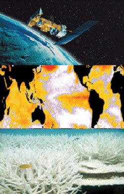 NOAA image showing satellite, sea surface temperature map, and coral bleaching. |
From 2000 to 2006, NOAA’s Coral Reef Conservation Program (CRCP) and partners have led efforts to locate and remove over 542 tons of marine debris from the Northwestern Hawaiian Islands (NWHI). These islands, now part of a Marine National Monument, are particularly prone to the accumulation of floating debris due to their central location in the North Pacific gyre. Most of the debris is derelict fishing gear that entangles and kills endangered Hawaiian monk seals, endangered green sea turtles, coral, and other wildlife. Future operations will include the removal of new marine debris accumulations each year. In 2006, CRCP scientists also led efforts to assess the extent and impact of marine debris in the main Hawaiian Islands for the first time. Hot-spot debris areas were located via aerial surveys, and these data used to create maps of debris distribution and abundance. Surveys of Kauai, Molokai, Lanai, Maui, Oahu, and the Big Island of Hawaii are now complete. As in the NWHI, the marine debris problem in the main Hawaiian Islands has proven to be greater than expected, with over 650 debris sites reported. These maps will aid communities and federal, state, and local coastal managers to identify and prioritize clean-up areas and target sites for future monitoring.
In January 2006, NOAA published in the Federal Register the Final Rule revising NOAA’s CZMA federal consistency regulations. This is a major accomplishment for NOAA as well as DOI. The Final Rule is the result of a three-and-a-half-year effort to respond to the Vice President’s Report of the National Energy Policy Development Group, as well as the Energy Policy Act of 2005. The rulemaking process involved a close working partnership with DOI; greatly improving interagency relations; and involving coordination with the Department of Energy (DOE), the Federal Energy Regulatory Commission, the Vice President’s Office, the Council on Environmental Quality, and the Office of Management and Budget (OMB). The Final Rule contains improvements to CZMA federal consistency regulations. The revised regulations continue to balance the state-federal-private interests embodied in the CZMA, while providing for more efficient approval of both energy and non-energy projects by providing greater clarity, transparency, and predictability in the regulatory process. The Final Rule fully maintains the authority of coastal states to review proposed federal actions that have reasonably foreseeable effects on a state’s coastal uses or resources, as provided for in the CZMA and NOAA’s implementing regulations, as revised in 2000.
NOAA released the Gray’s Reef National Marine Sanctuary Final Management Plan. The plan updates research, monitoring, enforcement, exploration, administration, and education programs that are intended to enhance conservation with compatible public and private uses in Gray’s Reef Sanctuary. There are two notable changes—prohibiting anchoring in the sanctuary and revised regulations to allow fishing only with rod and reel, handline, and spearfishing gear without powerheads. The regulations apply to all sanctuary users and were adopted after extensive public input including recommendations from Gray’s Reef Sanctuary Advisory Council, other state and federal agencies, and approximately 1,800 public comments. Similarly, NOAA released a draft document for a revised management plan and proposed rule in Channel Islands National Marine Sanctuary to establish no-take and limited take marine zones.
NOAA released a report on the status of U.S. marine fisheries for 2005. The government report shows both progress in rebuilding overfished species and response of fisheries managers to slow fishing rates for species that were found in 2005 to have above-target harvests. Each year, NOAA announces the state of U.S. fisheries to inform Congress and the U.S. public of the Agency’s progress in restoring fish stocks to sustainable population levels. The annual report tracks both population levels and harvest rates for species caught in federal marine waters, between three and 200 miles off U.S. coasts. In 2005, NOAA scientists determined population levels for 206 fish stocks and multi-species groupings known as complexes. Of these, 152 (74 percent) were not overfished. NOAA scientists also determined the harvest rates for 237 stocks and found that 192 (81 percent) were not subject to overfishing.
NOAA has implemented plans to rebuild the 54 overfished stocks within the last eight years which, in some cases, is not enough time for them to recover from previous decades of substantial overfishing. Although overfishing still occurs on 45 fish stocks and complexes, the regional fishery management councils have been taking action to scale back the rate of overfishing. In many cases, rebuilding plans phase out overfishing over time to prevent major social and economic impacts to fishing communities, as required by the Magnuson-Stevens Act.
 |
NOAA scientists collect and analyze data to determine population levels and fishing rates for the major species targeted by recreational and commercial fishermen. While NOAA does not evaluate populations of every marine species, the Agency continues to assess the health of more species each year. In 2005, new assessments helped NOAA determine population levels and/or fishing rates for 20 additional stocks and stock complexes.
When a fish stock is determined to be either overfished or subject to overfishing, the regional fishery management councils must develop a plan to correct the problem. The councils were notified of the four new overfished and seven new overfishing determinations for 2005, and have taken corrective action or are scheduled to take action this summer.
NMFS is dedicated to protecting and preserving the nation’s living marine resources and their habitats through scientific research, management and enforcement. NMFS provides effective stewardship of these resources for the benefit of the nation, supporting coastal communities that depend upon them, and helping to provide safe and healthy seafood to consumers and recreational opportunities for the U.S. public.
NOAA made important strides in designating and protecting essential fish habitat by establishing the 279,114 square nautical mile Aleutian Islands Habitat Conservation Area and designating 150,000 square miles of Pacific marine waters from Canada to Mexico as essential fish habitat. The Aleutian Islands Habitat Conservation Area—an area of the Alaskan sea floor approximately the size of Texas and Colorado combined—was closed to bottom-contact fishing gear to protect sensitive habitats, including vulnerable coral gardens first discovered by NOAA scientists in 2002. The essential fish habitat designations in the Pacific, and the accompanying bottom gear restrictions, will serve to replenish stocks of Pacific Coast groundfish.
NOAA’s Habitat Program supported the restoration of 7,598 acres of habitat in 2006. A significant portion of this restoration was accomplished through NOAA’s Community-based Restoration Program through partnerships with state, local, tribal, and non-governmental organizations (NGO). These partnerships leverage funds, often three to five times the NOAA contribution. Celebrating its 10-year anniversary this year, the Community-based Restoration Program has implemented more than 1,300 coastal restoration projects restoring over 30,000 acres and 900 river miles with the contribution of more than 740,000 hours of community participation. The Agency also was responsible for opening 200 miles of rivers and streams to fish passage in 2006. The bulk of these miles were derived from the Community-based Restoration Program and the Agency’s hydropower program.
The Alaska fishing industry has started to electronically report landings of commercial fish and shellfish using one system shared by several agencies. The new Interagency Electronic Reporting System moves Alaska fisheries reporting into the modern era, leaving behind paper fish tickets and consolidating the reporting requirements of NMFS, the State of Alaska Department of Fish and Game, and the International Pacific Halibut Commission. The new system removes reporting duplications and will make reporting more straight forward for fishermen, processors, and managers.
The American Samoa Longline Limited Access Program was implemented December 1, 2005. In response to a dramatic increase in the number of longliners operating in the waters around American Samoa, NOAA now requires an American Samoa longline permit to catch pelagic fish with longline gear around American Samoa. The program will prevent fishing gear conflicts, maintain average albacore catch rates in the domestic longline fishery at optimum yield, provide for sustained community participation, ensure opportunities for future participation in the fishery by indigenous American Somoans, minimize bycatch, and preclude waste of pelagic management unit species.
NMFS completed the Consolidated Atlantic Highly Migratory Species Fishery Management plan in 2006. This rulemaking addresses phase 1 of the 5-year essential fish habitat review, workshops, time/area closures, overfishing of finetooth sharks, rebuilding of northern albacore tuna, bluefin tuna effort controls and in-season actions, fishing years, authorized gears, billfish mortality, and some regulatory housekeeping issues.
NOAA published the final rule for the longline catcher processor non-pollock groundfish buyback in the Federal Register on September 29, 2006. The program would provide a loan of up to $36 million in exchange for relinquishing non-interim Federal License Limitation Program groundfish licenses endorsed for Bering Sea or Aleutian Islands catcher processor activity, as well as any present or future claims of eligibility for any fishing privilege based on such permit. This project had an extremely ambitious time frame which included completing the rulemaking process in less than six months.
NOAA mounted a multi-pronged effort to address fishery-related impacts in the Gulf of Mexico. In August 2006, NOAA awarded $128 million, the largest grant in its history, to the Gulf States Marine Fisheries Commission to reseed and restore oysterbeds and to conduct fisheries monitoring in the Gulf. NOAA also conducted research surveys and monitored the seafood coming from the Gulf to ensure it was safe from PCBs, pesticides, and fossil fuels. Changes in species abundance as a result of the general decrease in fishing effort continue to be tracked monthly and will be used to help managers in the future to determine optimal effort. Marine debris removal efforts focused on protecting fishing grounds. NOAA also completed survey of damage to the industry-related infrastructure in Gulf states.
NOAA scientists are now developing and implementing ecologically broad models to assess living marine resources in the context of the entire ecosystems in which they exist. These ecosystem assessments and forecasts are a key component of reaching NOAA’s strategic goal of implementing an ecosystem approach to management. The first of these assessments focused on the Bering Sea, the Gulf of Alaska, and the Gulf of Maine-Georges Bank-Middle Atlantic Bight ecosystems. Future ecosystem assessments will include sub-regions within the California Current, Pacific Islands Complex, South Atlantic, Gulf of Mexico, Caribbean and Antarctic Large Regional Marine Areas.
NOAA also led a collaborative effort to develop Fisheries Ecosystem Planning for Chesapeake Bay. Published by the American Fisheries Society in the fall of 2006, it is a guide to ecosystem-based resource management—a conceptual framework that promotes incorporation of established ecosystem principles into both fisheries and nonfisheries management. Revisions to existing Bay-wide fisheries management plans are under way to begin the transition from traditional single species plans, to multispecies plans, and finally true ecosystem-based fisheries management plans.
NOAA published a proposed rule describing regulations to reduce the risk of collisions between North Atlantic right whales and ocean-going vessels. The rule, negotiated with federal agencies and the shipping industry, proposes a speed restriction of 10 knots or less in three major regions along the U.S. east coast, based on seasonal occurrence of whales in each area, as well as commercial ship traffic patterns and navigational concerns. The right whale population numbers about 300 individuals, making it one of the most critically endangered species in the world. Existing conservation measures have not been sufficient to reduce right whale deaths and serious injuries associated with ship strikes.
NOAA successfully implemented the hydropower provisions of the Energy Policy Act for two high priority and high profile hydropower projects: the Klamath (CA/OR) and Santee Cooper (SC) projects. Fish passage past the Klamath project would restore access to more than 350 miles of historic habitat in the Klamath Basin for salmon, lamprey, and resident trout. Historically, the Klamath Basin has been the third most productive salmon river system on the west coast. Fish passage past the Santee Cooper Project would restore access to over 300 miles of historic habitat in the Santee River Basin for species such as American shad, river herring, striped bass, and the endangered shortnose sturgeon.
NOAA listed the southern resident killer whale as an endangered species in November 2005. NOAA has worked to further its understanding of this species distribution, abundance, and fecundity, and the causes for its decline in the Pacific Northwest. Threats to this species include vessel interactions in Puget Sound (whale watching) and a severe decline of salmon, its primary nutritional source.
NOAA scientists in the Pacific Islands carried out population surveys and assessments of endangered Hawaiian monk seals in the recently designated Northwestern Hawaiian Islands Marine National Monument. These assessments and other conservation efforts are part of an ongoing effort to prevent extinction of this species. Monk seal numbers have declined to 1,200 individuals, and their numbers are expected to fall to or below 1,000 by 2011. NOAA took twin female monk seal pups into to captivity in early summer 2006 for rehabilitation and future release back to the wild. Twinning in monk seals is rare, and pup survival has been low for more than 10 years. Because Hawaiian monk seals are critically endangered, each individual represents a significant contribution to the population; therefore, these pups, which would have little chance of survival without human intervention, were removed for rehabilitation.
Excess fishing capacity is a key obstacle to meeting the objectives of sustainable fisheries. In March 2006, NOAA completed the report, Assessments of Excess Fishing Capacity in Select Federally-Managed Commercial Fisheries. The report provides assessments of excess fishing capacity for select federally-managed fisheries, and it demonstrates methods for assessing excess fishing capacity that can be used in other fisheries. Overall, the assessments found evidence of significant excess capacity in the majority of fisheries and fleets analyzed.
NMFS worked closely with the U.S. Navy to issue a Marine Mammal Protection Act (MMPA) incidental take authorization for the RIMPAC training exercises conducted in waters around Hawaii in July of 2006. RIMPAC is a multi-national training exercise, led by the United States, that includes the use of tactical military sonar in anti-submarine warfare. This was the first-ever MMPA incidental take authorization issued to the U.S. Navy for military sonar.
NMFS worked closely with members of the oil and gas industry to authorize several seismic surveys of potential oil and gas resources on the outer continental shelf in the Alaskan Arctic in FY 2006. These surveys were conducted in the Beaufort and Chuckchi Seas and represent important steps towards future development and production of offshore oil and gas resources in the region.
| Rating | Results |
|---|---|
| Exceeded Target | 0 |
| On Target | 4 |
| Slightly Below Target | 0 |
| Below Target | 2 |
| See Appendix A: Performance and Resource Tables for individual reported results. | |
Some highlights from this performance goal in FY 2006 include:
The Tampa Bay economy receives more than $7 million a year in savings and direct income from the operation of the Physical Oceanographic Real-Time System (PORTS®), according to a new NOAA sponsored study. The report details the first study of the navigational aid, which is in operation at 13 major ports across the United States. Tampa’s PORTS® system provides accurate real-time oceanographic information tailored to the specific needs of the 6,700 commercial vessels transiting Tampa Bay each year.
The PORTS® system is a good example of how research and observing system development expertise can be applied to support safe, efficient, and environmentally sound marine transportation. Tampa Bay PORTS® is an excellent example of NOAA’S creativity and technological expertise. The Tampa Bay maritime users have realized enhanced navigational safety while transiting the long channels of the harbor. This has resulted in more efficient loading logistics, enhanced vessel traffic management, and better protection of the environment and citizens of the Tampa Bay region. It is especially helpful for both planning and maintaining the flow of maritime commerce during periods of disturbed weather conditions.
This study validated what has been reported for anecdotally some time. It quantified the benefits as being far greater than the cost of the system and demonstrates that the system provides valuable support for the safe and efficient maritime commerce necessary for a healthy economy. The benefits are not just good, they are impressive.
The most significant change in the 1990s in maritime shipping operations in the bay occurred when Harbor pilots onboard vessels began using portable computers to access PORTS® in real-time. During this time, groundings decreased by half. With tankers accounting for 2,200 transits per year, the 50 percent reduction in groundings translates into a conservative estimate of $2.8 million in avoided costs annually. The PORTS® system was installed in Tampa in 1990.
The system provides real-time data available to load ships to drafts 12 inches or more above what had been considered the safe guideline. The additional capacity for the phosphate trade alone in Tampa Bay could equal an increased benefit of $1.1 million each year.
Even though hazardous chemical spills in Tampa Bay are rare, at a conservative estimate the additional efficiency and accuracy of applying these data would avoid nearly $1.8 million per year in losses.
PORTS® data are used to enhance area weather and coastal marine forecasts, particularly coastal flooding. Tampa Bay is considered one of the most storm surge threatened areas in the country because of its large coastal population and its geography. Applying PORTS® data risk formulas for forecasts in the area gives it an estimated yearly value of $2 million.
Recreational boaters, using better real-time information available through PORTS®, may make more excursions, bringing an estimated $946,000 to the economy each year. Fishermen looking for water temperature and tidal data to improve their catch contribute another estimated $150,000 per year in port area income.
The report was authored by Hauke Kite-Powell, Ph.D., of the Woods Hole Oceanographic Institute Marine Policy Center, who designed the method of identifying as well as collecting and quantifying the data. The Tampa study was the first application of the methodology, which NOAA plans to use in evaluation of PORTS® systems in Houston in 2006 and New York in 2007.
PORTS® systems also operate in San Francisco Bay; Chesapeake Bay, which serves Delaware, Maryland, and Virginia; Narragansett Bay, RI; Soo Locks, MI; Los Angeles/Long Beach, CA; Delaware River and Bay; Tacoma, WA; Port of Anchorage, AK; New Haven, CT, and the Lower Columbia River, bordering Oregon and Washington.
Mariners can now get free electronic downloads of NOAA Raster Navigational Charts (RNC). A raster chart is a digitally scanned image of a paper nautical chart used by mariners for navigation.
The raster navigational charts contribute to safe, efficient, and environmentally sound marine transportation. By providing these charts for free, NOAA offers easy access to mariners to make navigation safer in U.S. waters.
 NOAA image of NOAA Raster Navigational Chart. |
Before the 1990s, NOAA’s paper nautical charts were created and maintained by hand engraving photographic images. NOAA electronically scanned all of its paper charts in the 1990s. Recently, the raster charts were incorporated into international standards for electronic chart systems and are now accepted as meeting international chart regulations for Safety of Life at Sea (SOLAS) vessels. SOLAS is a designation of the International Maritime Organization and usually is reserved for large merchant ships.
NOAA will produce official raster charts and deliver weekly updates with Notice to Mariners—notices containing changes in local navigational information. The NOAA Web site will contain a fully updated raster chart for each chart in NOAA’s suite. A cumulative file of updates with Notice to Mariner information for each chart edition will be posted on the Web site.
NOAA will distribute the free raster charts and updates the same way it distributes NOAA ENCs online.
The NOAA Coast Survey anticipates establishing a program where commercial value-added providers may download the raster charts for free, compress, encrypt, and/or package them with additional data or services, and then may sell that product. By adhering to a set of NOAA-specified practices, these raster charts will retain their official status and their original high quality and accuracy. No date has been set by which the value-added redistributors program will be in place.
NOAA also plans to make the raster charts available on the Web site in an easy-to-view format for non-navigational purposes, such as port security and management, marine boundary delineation, coastal zone management, and environmental assessment and spill response.
 NOAA illustration of NOAA satellite used to search and rescue mariners and hikers. |
As summer weather brings out more boaters, campers, and hikers, NOAA satellites and search and rescue staff are prepared to handle distress signals from emergency locator beacons. NOAA’s polar and geostationary satellites, along with Russia’s Cospas spacecraft, are part of the sophisticated, international Search and Rescue Satellite-Aided Tracking System, called COSPAS-SARSAT. The SARSAT system uses a network of satellites to quickly detect and locate distress signals from emergency beacons onboard aircraft, boats, and from hand-held personal locator beacons. When a satellite pinpoints a distress location within the United States, or its surrounding waters, the information is relayed to the SARSAT Mission Control Center in Suitland, MD, and sent to a Rescue Coordination Center operated by either the U.S. Air Force (for land rescues), or U.S. Coast Guard (for water rescues).
"This program stands vigilant so that people can responsibly take part in outdoor recreation with less fear of harm, injury or death,” said Ajay Mehta, NOAA’s SARSAT program manager. “SARSAT is crucial because it can literally be the difference between life and death.”
The system uses a constellation of satellites to detect and locate distress signals from emergency beacons onboard aircraft, boats, and from hand-held personal locator beacons. Once the satellites pinpoint the location of the distress within the United States or surrounding waters, the information is relayed to the SARSAT Mission Control Center in Suitland, MD, and sent to a Rescue Coordination Center, operated by either the U.S. Air Force (for land rescues), or U.S. Coast Guard (for water rescues).
"The SARSAT program is doing exactly what it was intended to do—save lives,” said retired Navy Vice Admiral Conrad C. Lautenbacher, Ph.D, Undersecretary of Commerce for Oceans and Atmosphere and NOAA administrator. “NOAA satellites and the quick responses of the U.S. Air Force and Coast Guard continue to be the difference between life and death.”
Since its creation in 1982, COSPAS-SARSAT has been credited with more than 18,500 rescues worldwide, and 5,107 within the United States and its surrounding waters. Most of the rescues each year happen at sea. Alaska led the nation with 65 rescues in 2005; followed by Florida (49 rescues); and Louisiana, California, and Hawaii rounding out the top five with 13, 12, and 10 saves respectively.
Older emergency beacons, which operate on the 121.5 and 243 megahertz frequency, will be phased out by early 2009, when 406 megahertz beacons will be the standard. Emergency beacon owners can register their devices online using the National Beacon Registration Database.
NOAA provided hurricane damage assessment by responding rapidly to two tropical systems that made landfall along the United States coastline. Following the landfall of Hurricane Rita, NOAA performed aerial surveys that collected over 3,000 high resolution digital images from Galveston, TX, to just west of the Lake Charles, LA. NOAA responded to Hurricane Wilma by collecting approximately 1,600 high resolution digital images, covering selected areas from the Naples, FL vicinity south through the Florida Keys. The high resolution aerial imagery collected during both incident response efforts was disseminated via the Internet to federal, state, and local government agencies, as well as the general public within 24 hours of acquisition. The data was critical to national and local response efforts and to the timely assessment of personal and property damages sought by the general public and insurance industry.
NOAA’s NGS’s Coastal Mapping Program (CMP) evaluated 11 of the 40 Priority Port Areas (27.5 percent) for changes in shoreline and critical port infrastructure. This was done by comparing the latest NOAA ENC and raster chart products to new commercial satellite imagery and aerial photography, as part of the Coast and Shoreline Change Analysis Program (CSCAP). In addition, the CMP delivered updated shoreline and coastal feature data for over 4,000 miles of U.S. shoreline, compiled from aerial and satellite imagery, for application to NOAA nautical charts and to support hydrographic survey operations. Aerial imagery acquisition, data processing, and shoreline compilation were accomplished through a combination of in-house work and external contracts.
This spring, the Joint Planning and Development Office’s (JPDO’s) Weather Integrated Product Team (WxIPT), led by the Department, released its Next Generation Air Transportation System (NGATS) Aviation Weather Concept of Operations. This document draws upon the experience of members of the JPDO’s constituent agencies, industry, and academia to present a comprehensive view of the future of aviation weather and its use in the NGATS. The vision of this concept of operations is to integrate weather information into the automated and manual decision-making processes available to the users of the National Airspace System as they plan and execute flights. The Aviation Services Branch of NOAA’s NWS is aligning its planning activities with this vision to ensure compatibility with the JPDO effort and the user community’s need for aviation weather services. The full document can be found at http://techhangar.jpdo.aero.
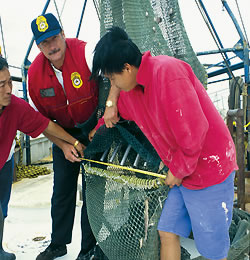 Working with shrimp and longline fishermen, NOAA scientists have developed a new, soft Turtle Excluder Device (TED) and a highly effective double-flap hard TED that the shrimp industry has adopted to reduce the incidental capture of endangered and threatened sea turtles. |
Consistent with the U.S. Ocean Action Plan and U.S. Commission on Ocean Policy Report, NOAA has adopted an ecosystem approach to management that will evolve over time in col-laboration with its partners.
NOAA is implementing the call by its stakeholders to move towards an ecosystem approach to managing uses of coastal and marine resources. NOAA is integrating the application of its multiple ecosystem mandates in partnership with universities; industry; NGOs; and local, state, and federal agencies by developing and implementing ecosystem approaches to management of coastal and marine resources.
NOAA is seeking improved understanding of ecosystems, identification of regional ecosystems, development of ecosystem health indicators, and new methods of governance to establish the necessary knowledge, tools, and capabilities to fully implement ecosystem approaches to managing coastal, ocean, and Great Lakes resources. Advancement in NOAA’s performance measurement for an ecosystem approach to management is underway for FY 2006.
 NOAA surveys 95,000 nautical miles of U.S. coastline to provide an accurate and official delineation of the national shoreline for nautical chart production and coastal resource management. |
NOAA helps transportation information users and stakeholders reach their goals with the following strategies identified in the five-year NOAA strategic plan:
In the future, NOAA plans to enhance the intermodal transportation network by improving available products and services and investing in transportation related observing systems. For example, NOAA will continue to build and maintain its suite of ENCs to supply commercial and recreational mariners with the digital navigation data they need to navigate safely in the 21st century. Additionally, NOAA will focus on equipping all 195 NWLON stations with real-time operational capability at the top 175 U.S. seaports. Enhanced ice forecasts and refinements to aviation, marine, and surface weather predictions will also contribute to NOAA’s role in saving lives, property, and critical infrastructure. NOAA will continue to survey and chart U.S. waters, maintain the highly accurate positioning infrastructure the nation relies on each day, support Satellite Search and Rescue incidents, respond to hazardous material events, and support U.S. national interests in commercial remote sensing licensing. It is through these and other important activities that NOAA strives to improve and deliver information crucial to safe and efficient transportation.
The Department’s response to addressing the transportation challenges facing the nation include building on the foundation of expertise, research, and technology development to deliver the information, tools, and services essential to safe, efficient, and environmentally sound transport on water, land, and in the air. Impacts to the system, particularly at vulnerable choke points, affect transit time, delivery reliability, efficiency, cost of goods transported, and the environment. To improve service delivery, NOAA consults with its stakeholders to identify valid user needs that cannot be met with existing information; enhance products that support transportation systems; work with partners to conduct research and development in weather, modeling, and geopositioning; and improve the translation of research into operational value. NOAA must also focus on connecting and strengthening its observations systems that gather data for transportation information.
Provide critical support for NOAA’s mission
| FY 1999 | FY 2000 | FY 2001 | FY 20021 | FY 2003 | FY 2004 | FY 2005 | FY 2006 | |
|---|---|---|---|---|---|---|---|---|
| Fiscal Dollars | $0.0 | $0.0 | $0.0 | $313.5 | $250.5 | $1,217.6 | $1,354.5 | $1,584.0 |
| FTE – Full-Time Equivalent | 0.0 | 0.0 | 0.0 | 1,716 | 1,996 | 2,178 | 2,437 | 2,880 |
| 1. In FY 2002, NOAA created a Mission Support goal that covered activities spanning both objectives and all four performance goals. The Mission Support goal does not currently have performance measures. Funding and FTE were split off from the other performance goals. Consequently, the funding and FTE for objectives 3.1 and 3.2 began to decline in FY 2002, with those amounts appearing in the Mission Support goal. (back) | ||||||||
There are no Government Performance Results Act (GPRA) measures for the Mission Support goal since the activities of this goal support the outcomes of the Mission goals. NOAA is developing new and improving existing internal management performance measures for the Mission Support goal.
 NOAA theme collage. |
Students from colleges and universities in 36 states and Puerto Rico are spending most of their summer in NOAA laboratories or programs as part of the Hollings Scholarship Program. The scholarship program, named after former Senator Ernest F. Hollings of South Carolina, a strong supporter of science education, began in 2005 with the summer internship assignments starting in the summer of 2006.
The program began May 30, 2006 and ended the first week of August 2006 with a series of workshops in Silver Spring, MD. The 110 students are engaged in a wide variety of projects, including conducting fisheries surveys, engineering remotely operated underwater vehicles, studying the carbon flux in marine waters, forecasting seabreeze and lightning, monitoring tornado processes, analyzing storm data, identifying acoustic signatures of marine mammals, evaluating sea bass habitat, and participating in studies of the Antarctic climate.
These scholarships provide the hands-on training and experience to encourage undergraduates to pursue study in the NOAA fields, such as atmospheric or oceanic science, research, and technology. NOAA is very pleased with the quality and the quantity of scholarship recipients in this first year.
The NOAA Hollings scholarship program is designed to increase undergraduate training in oceanic and atmospheric science, research, technology, and education and foster multidisciplinary training opportunities; to increase public understanding and support for stewardship of the ocean and atmosphere and improve environmental literacy; to recruit and prepare students for public service careers with NOAA and other natural resource and science agencies at the federal, state, and local levels of government; and to recruit and prepare students for careers as teachers and educators in oceanic and atmospheric science and to improve scientific and environmental education in the United States.
Scholarship students are eligible for up to $8,000 of academic assistance per year for full-time study during the junior and senior years, a 10-week, paid ($650/week) internship during the intervening summer, housing subsidy during the internship, round-trip travel to the internship site, and travel expenses to the Hollings scholarship program conference in Silver Spring.
To be eligible, students must be U.S. citizens; a full-time junior in an accredited college or university within the United States or U.S. Territories; hold a cumulative grade point average of 3.0 (based on a 4.0 scale) in all completed undergraduate courses, and major in a discipline area related to oceanic and atmospheric science, research, technology, or education; and supportive of the purposes of NOAA’s programs and mission (biological, social, and physical sciences; mathematics; engineering; computer and information sciences; or teacher education).
|
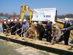
The General Services Administration (GSA), in partnership with NOAA and Opus East, L.L.C., broke ground for the NOAA Center for Weather and Climate Prediction, the crown jewel in a new 50-acre section of the University of Maryland’s M-Square Research and Technology Park. Opus East, L.L.C., of Rockville, MD., working with Hellmuth, Obata + Kassabaum, Inc. (HOK) as the lead design and interior architect, will design, construct, and own the building and lease it to the GSA. Opus arranged a long-term ground lease with the University of Maryland for the development. The 268,762 square-foot office and research complex will become the new headquarters for the NWS National Center for Environmental Prediction (NCEP). Approximately 800 people will work in the facility.
By locating this facility adjacent to the University of Maryland, GSA enhances NOAA’s ability to develop closer collaboration between its scientists and forecasters, and the faculty and students at the University of Maryland. This benefits NOAA, the University, and the American people.
Virtually all the meteorological data collected globally will arrive at NOAA’s Center for Weather and Climate Prediction. Environmental scientists will analyze this information and generate a wide variety of atmospheric and oceanic forecasts and guidance products using sophisticated numerical weather and climate prediction models.
With the groundbreaking for this new $125 million facility in College Park, NOAA is continuing to ensure that the nation’s top scientists, researchers, and other professionals have the state-of-the art facilities and tools to match their talents so that they can continue to perform NOAA’s vital mission. “We take great pride in having NOAA located here in Maryland and in the men and women who will work here continuing to contribute to the well being and the protection of our natural resources,” said Senator Paul S. Sarbanes.
"This is a significant milestone towards completion of the new NOAA Center for Weather and Climate Prediction, which will be a state-of-the-art advanced weather operations and research facility,” said Congressman Steny H. Hoyer. “This critical project will not only vastly improve our nation’s weather systems and be much better suited to meet NOAA’s needs, but it will also ensure that our region remains an attractive destination and home for the best and brightest minds.”