Strategic Objective 3.1
Advance understanding and predict changes in the Earth’s environment to meet America’s economic, social, and environmental needs
The Department’s role in understanding, observing, forecasting, and warning of weather events is expanding. The Department is strategically positioned to conduct sound, scientific research and pro-vide integrated observations, predictions, and advice for decisionmakers who manage environmental resources, ranging from fresh water supplies to coastal ecosystems to air quality. Realizing that the Department’s information and services bridge both weather and climate timescales, the Department will continue to collect and analyze environmental data and issue forecasts and warnings that help protect life and property and enhance the U.S. economy. The Department is committed to excellent customer service and depends on its partners in the private sector, academia, and government to add value and help disseminate critical weather and climate information. The Department will expand services to support evolving national needs, including those associated with space weather, freshwater and coastal ecosystems, and air quality prediction.
Performance Goal: Serve society’s needs for weather and water information (NOAA)
|
|||||||||||||||||||||||||||||||||||||||||||||||||||||||||||||||||||||||||||||||||||||||||||||||||||||||||||||||||||||||||||||||||||||||||||||||||||||||
| Rating | Results |
|---|---|
| Exceeded Target | 0 |
| On Target | 6 |
| Slightly Below Target | 4 |
| Below Target | 0 |
| See Appendix A: Performance and Resource Tables for individual reported results. | |
In FY 2006 NOAA continued its leadership in weather and water science and technology by expanding sources of observational data, advancing numerical models, and improving the accuracy of its forecasts and warnings. In addition, NOAA responded to society’s evolving needs for forecast services by leveraging its partnerships in the public, private, and academic sector.
Some highlights from FY 2006 include:
The most significant accomplishment of the Telecommunications Operations Center (TOC) was reaching Initial Operational Capability for the Replacement Telecommunications Gateway (RTG) system. NWSTG is the primary data communications switching system of the NWS. It is a global distributor of weather messages, and is located in the NWS TOC. This system can route more than 50 routine messages per second, within one minute, 99.9 percent of the time. Additionally, the system can route Watches, Warnings, and other perishable observation messages in 10 seconds, which directly supports dissemination systems supporting disaster management such as the Emergency Managers Weather Information Network, NWS offices, other government agencies, and the public in a timely manner so they can be most useful.
NOAA’s Earth System Research Laboratory (ESRL) weather model scientists joined forces with the National Center for Atmospheric Research (NCAR) to develop and test a new national model called Rapid Refresh that is designed to substantially improve NOAA’s forecasting skill. The Rapid Refresh is the next-generation version of the 1-h cycle system, to replace the current Rapid Update Cycle (RUC) forecast by 2008. This model will take advantage of the collaboratively developed, state-of-the-art Weather Research and Forecast (WRF) model. Rapid Refresh uses WRF’s optimal combination of numerical and physical parameterizations. The emphasis for the enhanced model is on aviation and severe weather applications in one to 12-hour forecasts.
The nation relies on numerical weather models and complex computer programs to process millions of weather observations and produce accurate and timely weather forecasts. Developers must make sure that models are both accurate and fast so that watches and warning can be issued with as much lead time as possible.
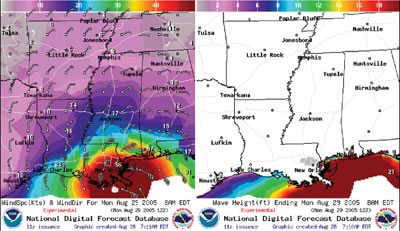 |
As the foundation of the NWS Digital Services Program, the NDFD consists of gridded forecasts of sensible weather elements (e.g., cloud cover, maximum temperature) in a seamless mosaic from NWS. In FY 2006 NWS upgraded four experimental elements (wind speed, wind direction, apparent temperature, and relative humidity) to operational status for the coterminous United States (CONUS), Puerto Rico/Virgin Islands, Hawaii, and Guam. Eight of the original 12 elements in NDFD are now operational. Several new experimental elements were added to NDFD this year, including the first set of experimental elements for Alaska: maximum temperature, minimum temperature, 12-hour probability of precipitation, wind direction, wind speed, and significant wave height. Adding these elements for Alaska is a first step in fulfilling a strong demand for high resolution gridded forecasts for Alaska from many national and local customers. Wind gust forecasts for the CONUS, Puerto Rico/Virgin Islands, Hawaii, and Guam; and six tropical cyclone surface wind speed probability elements for the CONUS and adjacent coastal areas were also introduced as new experimental elements in NDFD this year. Finally, changes were implemented to improve accessibility to the data in NDFD. Ongoing customer demand for additional data reflects the significant role the NDFD plays in weather-sensitive decision-making.
 NOAA illustration of a tornado. |
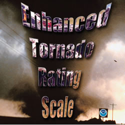
NWS announced plans to implement the Enhanced Fujita (EF) Scale to rate tornadoes to replace the original Fujita (F) Scale. The EF Scale will continue to rate tornadoes on a scale from zero to five, but ranges in wind speed will be more accurate with the improved rating scale. NWS has approved the EF Scale and expects it to be fully implemented by February 2007.
The EF Scale takes into account additional variables which will provide a more accurate indication of tornado strength. The EF Scale will provide more detailed guidelines that will allow NWS to more accurately rate tornadoes that strike in the United States. Limitations of the original F Scale may have led to inconsistent ratings, including possible overestimates of associated wind speeds. The EF Scale incorporates more damage indicators and degrees of damage than the original F Scale, allowing more detailed analysis and better correlation between damage and wind speed. The original F Scale historical database will not change. An F5 tornado rated years ago is still an F5, but the wind speed associated with the tornado may have been somewhat less than previously estimated. A correlation between the original F Scale and the EF Scale has been developed. This makes it possible to express ratings in terms of one scale to the other, preserving the historical database.
 NOAA illustration of the Real-Time Ocean Forecast System. |
The NOAA Environmental Modeling Center, Marine Modeling and Analysis Branch, has implemented a new revolutionary Real-Time Ocean Forecast System that will provide mariners with “nowcasts” and five-day forecasts for the entire North Atlantic Ocean. The Real-Time Ocean Forecast System generates applications that can support operations at sea such as search and rescue operations, containment of toxic spills, exploration of natural resources, fishing, recreation and much more.
Expanded ocean forecasting for areas from Europe to the U.S. east coast and from the Caribbean to Canada represents a major step in NOAA’s commitment to forecasting the Earth system. These new capabilities provide us with the potential to mitigate impacts from natural hazards and are just one example of the tangible benefits of an integrated observation system. Meteorologists, who focus on predicting the weather over the oceans, note that in the future this system will provide the foundation for the initial and boundary conditions for the ocean component of NOAA’s coupled ocean-hurricane prediction model, as well as the high-resolution regional models for environmental and ecosystem management, safety of marine transportation, and coastal flooding.
The inclusion of the new ocean prediction system will contribute to NOAA’s ongoing effort to improve hurricane track and intensity forecasts throughout the entire Atlantic Ocean basin.
The Real-Time Ocean Forecast System for the Atlantic Ocean produces daily “nowcasts” and five-day forecasts over the Atlantic Ocean domain of 25 degrees south to 70 degrees north and across the basin from west to east, including the Gulf of Mexico, Caribbean Sea, Gulf of Maine, and Gulf of St. Lawrence. The system replaces the regional Ocean Forecast system, which covered a limited part of the U.S. east coast.
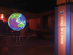
 NOAA image of a simulation of the Indian Ocean tsunami of December 2004 as projected on the NOAA Science on a Sphere exhibit at Nauticus, the National Maritime Center in Norfolk, VA. |
Work on the Real-Time Ocean Forecast System was partially supported through a National Ocean Partnership Project grant. It is the first in a series of the Environmental Modeling Center’s real-time, high-resolution ocean forecast system implementations over the next decade. Currently, global and Pacific Ocean (Earth’s largest body of water) versions of this system are under development.
Norfolk became the first major east coast city with a well designed tsunami emergency response plan to alert residents and visitors of tsunami threats, and evacuate areas if necessary. NOAA, the federal agency responsible for tsunami and all severe weather warnings, officially recognized the City of Norfolk as the latest of 26 TsunamiReady communities along U.S. coasts. Norfolk also was recognized as StormReady, becoming one of nearly 1,000 communities across the country with a proactive approach to warning and educating the public about tornadoes, flooding and other severe weather.
City officials and emergency managers have worked hard to establish a 24-hour system to receive NOAA warnings and inform Norfolk residents about what actions to take if a tsunami or severe weather is headed their way. NOAA has expanded its tsunami detection and warning capability since the Indian Ocean tsunami, and community preparedness programs like TsunamiReady are key components of this effort. Ultimately it is the public’s ability to react to such warnings that completes the chain in an effective tsunami warning process. TsunamiReady helps accomplish this.
Coastal communities like Norfolk contain 53 percent of the nation’s population. Protecting the growing population along the coastline from the ravages of natural disasters is a major concern in Virginia. Hurricane Isabel in 2003 was the costliest disaster ever in Virginia, with more than $1 billion in damages. All coastal communities in the United States are at some risk for a tsunami. NOAA is honored that the City of Norfolk is leading the way in preparedness with the designation of being both TsunamiReady and StormReady.
The City of Norfolk has made tremendous progress on educating its citizens about all natural disasters, from hurricanes to tornadoes and winter storms, to east coast tsunamis. This program will enable the city to apply for additional reductions in the premiums paid into the National Flood Insurance Program, which could result in an additional savings of over $100,000 for the city and local taxpayers.
Norfolk also became the fifth Hampton Roads community to earn the StormReady designation. TsunamiReady is an outgrowth of the StormReady program created by NWS in 1999 to encourage communities to take a proactive approach to improving local hazardous weather operations and public awareness. The voluntary program provides communities with clear-cut advice through a partnership between local NWS offices and state and local emergency managers.
StormReady and TsunamiReady help us create better prepared communities throughout the country. Through StormReady and TsunamiReady, the City of Norfolk will be better prepared to help protect the lives and property of its citizens and visitors during severe weather events, as well as for the rare, but potentially devastating tsunami.
|
|
 NOAA illustration of NOWData Web portal for getting weather and climate data. |
Finding climate information, such as past weather conditions and temperature and precipitation averages and extremes, can be easily achieved through NOWData (NOAA Online Weather Data)—a tab click away on the newly-standardized climate pages of the 122 local NWS forecast offices.
By visiting NWS’s national climate Web portal, users can click a desired location on a national map and be taken directly to the local climate page of the appropriate NWS forecast office. Then, by clicking on the NOWData tab, users can access a wide range of climate products for nearly 3,900 locations. Daily past weather is available for the last two years with climate averages for the standard 30-year period of 1971-2000 and extremes for as long as a station has been taking observations.
NOWData enhances access to recent past weather information, which is often the focus of questions NWS receives from the public. NOWData stems from the collaboration between the NOAA Office of Climate, Water, & Weather Services, part of NWS, which provides weather and water services to the United States, American Samoa, Guam, and Puerto Rico; the NOAA National Climatic Data Center (NCDC), the official archives of U.S. weather and climate information; and the nation’s six Regional Climate Centers that operate the database, which supports NOWData.
NOWData is a potentially vast educational resource for teachers and students undertaking weather and climate-related projects. NOWData is a source of data that is collected by instruments that are components of the GEOSS.
Past weather data offered by NWS forecast offices and linked from the NOWData Web site are considered preliminary, and therefore, unofficial. Certified weather data, for uses such as litigation, are available only through the NOAA NCDC.
In FY 2005, in response to the Indian Ocean tsunami, NOAA established a Tsunami Warning Program. The Center for Operational Oceanographic Products and Services’ (CO-OPS) role in the Program is Sea Level Monitoring for tsunami detection. NOAA monitors sea height through a network of buoys and tide gauges. This information is critical to understanding the time of arrival and the height the tsunami wave will be when it comes ashore. CO-OPS completed the addition of 16 new NWLON stations this year to fill critical observation gaps in the detection network. These 16 stations were installed in California, Oregon, Washington, Alaska, Puerto Rico, and the Virgin Islands. These and other new stations will bring the NWLON to 200 stations by the end of FY 2006. In addition, NOAA continued the upgrade of the entire NWLON to real-time status by replacing another 50 Data Collection Platforms. This is part of the Administration’s Ocean Action Plan and will be completed in FY 2007.
CO-OPS is pleased to announce that an IOOS-oriented Web portal is up and running: http://tidesandcurrents.noaa.gov/opendap.html. In partnership with the National Data Buoy Center (NDBC), CO-OPS created this IOOS Web site to provide access to NDBC and CO-OPS observational oceanographic data. The CO-OPS IOOS team designed the portal by following guidance presented in the Ocean U.S. Data Management and Communications Plan. Users will find improved methods for observational data retrieval, information concerning IOOS meetings, useful IOOS links, and related information.
NOAA launched three new operational coastal forecast systems for the Great Lakes this year to complete the Great Lakes Operational Forecast System (GLOFS). These new systems cover three Great Lakes (Superior, Huron, and Ontario) and provide lake carriers, mariners, port managers, emergency response teams, and recreational boaters with present and future conditions of water levels, water currents, and water temperatures. The GLOFS also includes the operational systems for Lake Erie and Michigan that were launched in 2005. The National Ocean Services (NOS) keeps the GLOFS operational 24 hours a day, seven days a week.
NOAA’s Estuarine Reserves Division and the National Estuarine Research Reserve System (NERRS) continued to expand their reach and programs in 2006 with the official designation of the twenty-seventh reserve in the system, Mission-Aransas in Texas. Mission-Aransas and its fellow reserves around the country will be guided over the next five years by a newly adopted strategic plan focusing on coastal and estuarine stewardship grounded in research and education. While celebrating the first 10 years of the system-wide monitoring plan, the reserve system also adopted a new research and monitoring plan to focus and integrate system-wide activities. The NERRS also has conducted a teacher needs assessment that will guide the development of education products based on water quality and weather data generated in the reserve system.
The year 2006 was the first of an expanded National Current Observation Program with current surveys undertaken in southeast Alaska, Penobscot Bay, ME, and Hudson River, NY. The collection of short-term tidal current observations will update old, potentially inaccurate, tidal current predictions and will be used to reintroduce historical products in an updated format. NOAA installed two long-term horizontal-looking current meters in the rivers and connecting channels of the Great Lakes. The current data from each meter will provide speed and direction of flow to assist all vessels to safely navigate these rivers. Data will be disseminated in real-time, accessible by telephone, and through the Great Lakes Online link at http://tidesandcurrents.noaa.gov/.
On June 29, 2006, NOAA officially opened the East Coast Node of NOAA’s CoastWatch program, which will broaden the availability of environmental data for the Atlantic Ocean collected by the Agency’s geostationary and polar-orbiting satellites. The East Coast Node, part of a network of other CoastWatch offices around the country, will be located at the NOAA Chesapeake Bay Office in Annapolis, MD. The new node will gather data, including sea surface temperature, ocean surface winds, and chlorophyll-a levels, and post the information on the Internet. Scientists, resource managers, and fishermen use these data to forecast atmospheric events, predict harmful algal blooms, and study fish and marine mammal distribution, along the eastern seaboard of the United States.
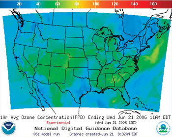 NOAA image of U.S. ozone forecast as of June 21, 2006, at 11 a.m. EDT. |
NWS, in partnership with the Environmental Protection Agency (EPA), provides experimental forecast guidance for ground-level ozone for the western half of the contiguous United States—a total of 17 states from the Plains to the Pacific coast. This is in addition to the air quality forecast guidance currently available for the eastern half of the United States. This new forecast guidance will provide accurate projections of ozone levels near the ground, linked to Agency weather forecast models. Weather and air quality go hand-in-hand. Daily weather conditions, such as temperature and wind, play an integral role in creating and trapping harmful ozone where people all work, play and breathe.
Hour-by-hour ozone forecasts, through midnight of the following day, are available online, providing information for the onset, severity, and duration of poor air quality for more than 290 million people from coast to coast. This product also serves as a tool that local and state air quality forecasters can use when creating daily air quality outlooks and issuing poor air alerts.
Air quality forecasts can help Americans reduce their exposure to ozone pollution, which is a special concern for children and people with asthma and other lung diseases. This expanded tool will help improve forecasts for cities across the country.
This new experimental guidance expands coverage westward to the Pacific Ocean and will enable additional state and local agencies to issue enhanced and more geographically specific ozone-based air quality warnings to the public. States included in this experimental expansion are Arizona, California, Colorado, Idaho, Montana, Nevada, New Mexico, Oregon, Utah, Washington, and Wyoming, and the remaining western portions of Kansas, Nebraska, North Dakota, Oklahoma, South Dakota, and Texas. The eastern halves of these states were included in last year’s expansion into the central United States. Air quality forecast guidance was first implemented into operations for the northeast quadrant of the United States in 2004.
The air quality forecast capability is being built by a team of NOAA and EPA scientists that develop, test, and implement improvements in the science of air quality forecasting for real-time predictions. NWS forecast models are used to drive simulations of atmospheric chemical conditions using pollutant emissions and monitoring data provided by EPA. Twice daily, supercomputers operated by the NOAA National Centers for Environmental Prediction (NCEP) produce ground-level ozone forecasts, which are available on NWS and EPA data servers.
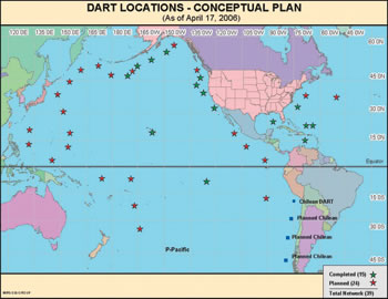 NOAA image of map of the conceptual plan for DART expansion. |
NOAA finished installation of five Deep-ocean Assessment and Reporting of Tsunami (DART) buoy stations off the East and Gulf coasts and the Caribbean as part of the expansion of the U.S. tsunami warning system. The latest buoy station, off New Orleans, joins stations off Charleston, SC; Miami, and two off San Juan, Puerto Rico.
Completing a three-week deployment mission aboard the University-National Oceanographic Laboratory System ship SEWARD JOHNSON, the fifth station was deployed.
These buoys are a first line of defense in providing citizens of the Atlantic, Caribbean and Gulf regions with a comprehensive tsunami warning system. The DART stations are an advanced technology that will help to protect densely populated, highly attractive tourist destinations in these regions as well as protect their significant economic resources.
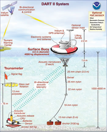 NOAA illustration of a DART buoy.. |
The DART system was designed and built by NOAA to provide real-time tsunami detection as the waves travel across the open ocean. The newly installed stations are a more robust DART-II, equipped with advanced two-way satellite communications that allow forecasters to receive and retrieve critical data. NOAA expects the network to total 39 DART-II buoy stations by 2008 (32 in the Pacific and seven in the Atlantic Basin).
NOAA’s tsunami warning centers have expanded their services to provide tsunami watches and warnings to the entire U.S. Atlantic coast, Gulf of Mexico, Puerto Rico, the U.S. Virgin Islands, and eastern Canada. These regions can now receive tsunami warnings and watches through NOAA Weather Radio All Hazards and the Emergency Alert System, just as they would be notified of tornadoes, flooding, or other hazards.
The DART network is one component in a comprehensive system to detect and warn the public of a tsunami threat. NOAA has made important strides in enhancing its communication networks so east coast residents and visitors can receive tsunami watches and warnings, upgrading its network of tide stations, working to staff its tsunami warning centers around the clock, producing forecast models for at-risk communities, transferring technology from research to operations, and providing public education.
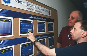 Blacksburg, Virginia, Warning Coordination Meteorologist Mike Emlaw, right, explains NWS performance goals to Pulaski County, Virginia, Emergency Manager Stan Crigger. All NWS office display the Agency’s performance measures similarly. |
In support of the National Tsunami Warning System, the Pacific Marine Environmental Laboratory deployed two DART-II buoys in Alaska while NOAA’s NDBC was recovering from Hurricane Katrina. DART-II technology utilizes the commercial Iridium satellite communications system and acoustic modems to send data between the DART-II system and shore side operators.
In addition to global coverage, lower power requirements, and increased bandwidth for an increased data rate, the improved DART-II buoys offer two-way communication capabilities that are not possible using the GOES satellite system employed in the DART-I system. For Tsunami Warning Center personnel, two-way communication offers the option to interrogate and command a DART-II before a tsunami is detected. This is valuable for observing a tsunami that is below the DART detection threshold. For engineering purposes, two-way communications allows engineers to troubleshoot the system from the lab, and to determine if the system can be repaired remotely. This new capability minimizes system downtime, especially in the harsh winter conditions of the North Pacific; and moreover, saves money by not having to deploy a ship to make this type of repair.
| Rating | Results |
|---|---|
| Exceeded Target | 1 |
| On Target | 4 |
| Slightly Below Target | 0 |
| Below Target | 1 |
| See Appendix A: Performance and Resource Tables for individual reported results. | |
Society exists in a highly variable climate system, with conditions changing over the span of seasons, years, decades, or even longer. Seasonal and interannual variations in climate, like El Niño, led to economic impacts on the order of $25 billion for 1997-1998, with property losses of over $2.5 billion and crop losses approaching $2.0 billion. Given such stresses as population growth, drought, and increasing demand for fresh water, it is essential for NOAA to provide reliable observations, forecasts, and assessments of climate, water, and ecosystems to enhance decisionmakers’ ability to minimize climate risks. This information supports decisions regarding community planning, business management, and natural resource and water planning. In the U.S. agricultural sector alone, better forecasts can be worth more than $300 million in avoided losses annually.
In FY 2006 NOAA continued its efforts to obtain the best science through the Climate Change Science Program (CCSP) and NOAA Climate Program. NOAA accomplished this through its continuing role as lead agency of the interagency CCSP. In addition, NOAA increased the production of climate information and services for decisions, including Synthesis and Assessment Reports, implementation of the National Integrated Drought Information System (NIDIS), and completion of initial climate scenario runs for the Intergovernmental Panel on Climate Change (IPCC).
Dan Albritton, Acting ESRL Director (retired) and Susan Solomon of the Chemical Sciences Division (CSD) of NOAA’s ESRL, have been recognized with the United Nations Environment Programme/World Meteorological Organization (UNEP/WMO) Vienna Convention Award. The award was presented as part of the celebration of the 20th Anniversary of the Vienna Convention for the Protection of the Ozone Layer. The Vienna Convention Awards were announced September 21, 2005 and were distributed at the Meeting of the Parties to the Montreal Protocol in Dakar, Senegal, in December. Through the Protocol and its subsequent Amendments and Adjustments, the production and use of ozone-depleting substances has plummeted worldwide.
NOAA invested over $6.4 million in 2006 to implement Height Modernization in the Gulf states. The goal of the Height Modernization program is to accurately and efficiently determine heights and monitor changes in elevation. Accurate elevations are critical to the rebuilding or lifting of homes, buildings, and levees. This project included obtaining accurate elevation profile data along 846.9 miles of hurricane evacuation routes and along 12.4 miles of hurricane protection levees in southern Louisiana. Critical to the post-hurricane rebuilding effort, NOAA published updated heights for approximately 300 bench marks in Louisiana based on new leveling surveys. NOAA’s National Geodetic Survey (NGS), in partnership with the Louisiana Spatial Reference Center (LSRC), also entered into an agreement with FEMA to take responsibility for responding to all elevation concerns in Louisiana and extending the network of accurate reference survey marks in the coastal areas of Louisiana affected by hurricanes Katrina and Rita.
SS2006 was a multi-agency effort lead by NOAA in collaboration with U.S. Coast Guard, California Office of Spill Prevention and Response, Harley Marine Services, and DOI. More than 300 people participated in training, field operations, oceanographic surveys, and incident command post activities. SS2006 exercised oil spill response preparedness in the Gulf of the Farallones and Monterey Bay National Marine Sanctuaries in the waters near San Francisco. The exercise highlighted capabilities to deliver data, observations, forecasts, and expertise towards the goal of protecting life, commerce, and the environment during an emergency. The exercise built on the oil spill preparedness efforts of governments, the private sector, and universities in California. Vessels and aircraft from NOAA, the U.S. Coast Guard, U.S. Air Force Reserve, Marine Spill Response Corporation, Alameda County Sheriff’s Department, and Bodega Marine Laboratory participated in the exercise. Additionally, the Central and Northern California Ocean Observing System will activate the new surface current mapping radar in support of exercise data requirements.
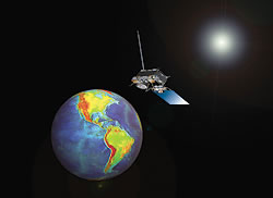 NOAA illustration of geostationary satellite orbiting the Earth. |
In Buenos Aires, NOAA, the Comisión Nacional de Activades Espaciales (CONAE), and the World Meteorological Organization (WMO) announced news of the repositioning of GOES-10. Shifting the spacecraft from its current position above the equator in the west to a new spot in orbit will greatly improve environmental satellite coverage of the Western hemisphere, especially over South America. The repositioning has already begun and should be completed this winter.
The shift will help protect lives and property in North, Central, and South America by significantly improving satellite detection of such natural hazards as severe storms, floods, drought, landslides, volcanic ash clouds, and wildfires. The shift will further strengthen the WMO’s World Weather Watch Global Observing System. It will allow for improved prediction, response, and follow-up, and expanded understanding of how the Earth system works. Nearly half the disasters in South America are caused by flooding. In February 2005, massive flooding and landslides in low-lying coastal areas of Venezuela, Guyana, and Colombia caused nearly 100 deaths and left tens of thousands of South Americans homeless.
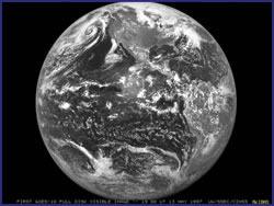 GOES-10 first full disk image taken on May 13, 1997 orbiting the Earth. |
”Repositioning NOAA’s GOES-10 geostationary satellite will help limit the effects of natural disasters in our region and improve energy and water resource management and over-all economic development, all key elements of the emerging GEOSS, of which Argentina is a member country,” said Conrado Franco Varotto, executive and technical director, CONAE, and chair, Committee on Earth Observation Satellites.
By linking many thousands of individual pieces of technology as one sustained, comprehensive global system, GEOSS will, over the next decade, integrate 21st century technology, making it more reflective of the planet it observes, predicts, and protects. In addition to Argentina and the United States, 58 other countries, the European Commission, and 43 international organizations are active supporters of GEOSS.
Strengthening satellite detection of severe weather and other natural hazards in the Western hemisphere will be a key element of the new global network. “A benchmark of GEOSS is full and open access and exchange of environmental satellite and other data, and the GOES-10 move enables the United States to improve the quality and quantity of data available to our Latin American partners, especially for near-term forecasting,” said retired Air Force Brig. Gen. John J. Kelly, Jr., NOAA deputy undersecretary for oceans and atmosphere, and the U.S. Permanent Representative to WMO.
Commodore Miguel Angel Rabiolo, general director of the Servicio Meteorológico Nacional of Argentina, said, “We are pleased with NOAA’s response to the South American hydro-meteorological community’s request for a more continuous data stream. The move of GOES-10 will allow us to optimize the availability of satellite information in order to improve weather monitoring and forecasting. Without any doubt, GEOSS, the Earth Observation Partnership of the Americas (EOPA) initiative, and the WMO Space Program play a critical role in the forecasting of severe meteorological events and in mitigating the effects of the natural disasters.”
Repositioning the spacecraft is part the EOPA initiative. Additionally, the president of the WMO Regional Association for South America requested that NOAA consider the shift. Through EOPA, NOAA is exploring partnerships with countries and scientific organizations in the Americas and the Caribbean to share Earth observations, develop and strengthen data networks, and enhance delivery of benefits to society. By ensuring that users in the Americas and Caribbean can receive and fully utilize data from current and next generation observing systems, EOPA will help both policymakers and other citizens understand their environment and make informed decisions of economic and other societal importance.
Through the emerging GEOSS, NOAA is working with its federal partners and nearly 60 countries to develop a global monitoring network that is as integrated as the planet it observes.
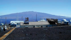
The NOAA Mauna Loa Observatory (MLO) in Hawaii marked its 50th anniversary as the premier atmospheric monitoring facility in the world. The facility was dedicated on June 28, 1956, as a site to measure solar radiation and atmospheric trace gases that could change Earth’s climate. It later began monitoring air quality and changes in the stratosphere, the latter primarily to track the ozone hole and its recovery. MLO is best known for its record of the continuous rise of carbon dioxide in Earth’s atmosphere, measurements originated by the late Charles David Keeling. MLO keeps tabs on more than 50 chemical species in Earth’s atmosphere.
MLO data on a host of atmospheric gases and aerosols, solar radiation, and standard meteorological measurements are freely available online, many in real time.
|
|
The Department utilizes several strategies, identified in the five-year NOAA strategic plan, to improve accuracy and timeliness of weather and water information. Improved weather and water information can have a profound impact on the economy. The Department strives to ensure that reliable, accurate, and timely weather and water information is available for informed and reasoned decision-making. Strategies to achieve this end state include:
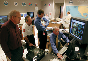 National Hurricane Center Director Max Mayfield previews Hurricane Michelle’s track for (from left) Jim Lushine, Warning Coordination Meteorologist, WFO, Miami; Chuck Lanza, Director, Emergency Management, Miami-Dade County; and an unidentified aide. |
One of NOAA’s top priorities is to effectively and efficiently deliver information and services to customers when they need it and in standardized formats. NOAA strives to support a safer, healthier, and economically stronger United States through reliable, timely, and accurate weather and water information. NOAA-wide information such as all-hazards warnings and a wide range of environmental information from an expanding customer base must be available in digital formats with the necessary supporting infrastructure.
NOAA will continue to provide critical services to the nation, including (1) advancing science to improve water resource forecasting and service delivery; (2) improving NOAA’s tsunami detection, warning, and mitigation capabilities and expanding its scope from the Pacific to the Atlantic and Caribbean; (3) conducting research to yield improvements in the accuracy of one-day to two-week high-impact weather forecasts; (4) improving international efforts to address medium range forecasting and climate variability; (5) expanding ozone air quality forecast to the rest of the nation; and (6) improving operational atmospheric, ocean, and coastal modeling capabilities.
NOAA must continue to refine its Earth observing architecture and data management infrastructure in order to increase its capacity to meet the information requirements of NOAA’s four mission goals. NOAA’s mission goals are directly related to the “nine societal benefit areas” identified by the intergovernmental Global Earth Observatory (GEO) and the U.S. Global Earth Observatory (USGEO). As such, NOAA will continue to be an active participant on both the USGEO, which is charged with developing the U.S. Integrated Surface Observing System (ISOS), and the GEO, which is developing GEOSS.
The Department utilizes several strategies identified in the five-year NOAA strategic plan to assist customers in better understanding the impacts of climate change and variability. Like weather, improved climate information can have a profound impact on the economy, and the Department strives to ensure that reliable, unbiased climate information is available for informed and reasoned decision-making. Strategies to achieve this end state include:
The Department’s Climate Program is aligned with the five goals of the CCSP in an effort to ensure optimal partnerships with other federal agencies and to advance the state of the science, while also enabling society to understand and respond to changing climate conditions. The program is working to improve the linkages among planning, budgeting, and performance management activities. The Climate Goal is also striving to develop more outcome and impact-oriented performance measures representative of the diverse research, development, and operational activities conducted within the Department. As these efforts are realized, the Department’s performance measures will be adjusted to evolve with the needs of the program.
 A NOAA scientist studies a real-time display of ozone and aerosol data for the New England Air Quality Study. |
The 21st century poses complex challenges for the Department. The Department must further the examination of land-water interfaces from an ecosystem perspective to successfully address ocean and coastal issues. NOAA’s strategic plan’s emphasis on the nation’s needs for expanded commerce and economic development that is safe and environmentally sound directly supports the Department’s focus on a healthy and growing economy.
As the new century unfolds, new priorities for NOAA action are emerging in the areas of climate change, freshwater supply, and ecosystem management. In recent years, extreme drought and flooding conditions in large regions of the nation have combined to make improved water resources prediction an urgent requirement for the Department’s future weather and climate mission.
The climate, weather, and water challenges that face the nation continue to grow as trends such as just in-time production, globalization, and increased travel amplify the impact of climate, weather, and water information services on the economy.
Substantial population and business growth in coastal and arid regions increases the sensitivity to climate, weather, and water conditions as well. This interdependence means climate, weather, and water events in one geographic area can have national and international economic impact.