Strategic Objective 3.2
Enhance the conservation and management of coastal and marine resources to meet America’s economic, social, and environmental needs
The Department works to protect, restore, and manage ocean and coastal resources. To meet this mandate, the Department maintains a world-class expertise in oceanography, marine ecology, fisheries management, conservation biology, and risk assessment. To achieve balance among ecological, environmental, and social influences, the Department has adopted an ecosystem approach to management–-an approach that is deliberate, incremental, and collaborative. Within the Department of Commerce, NOAA’s mission “to protect, restore, and manage fisheries and coastal and ocean resources” is critical to the health of the U.S. economy. To the extent it is possible to balance sustainable economic development and healthy functioning marine ecosystems, Commerce seeks to provide an example for the rest of the world in how to protect, restore, and manage resources of the world’s oceans and coasts. In addition, NOAA’s mission to support safe and efficient transportation systems is crucial to the U.S. economy. Department information improves transportation efficiency and safety on roads, rails, and waterways. The Department supports commerce through marine, aviation, and surface weather forecasts; the availability of accurate and advanced Electronic Navigational Charts (ENC); and the delivery of real-time oceanographic information. The Department provides consistent, accurate, and timely positioning information that is critical for air, sea, and surface transportation. The Department responds to hazardous material spills and provides search and rescue location support routinely to save lives and money and to protect the coastal environment. The Department works with port and coastal communities and with federal and state partners to ensure that port operations and development proceed efficiently and in an environmentally sound manner. The Department works with the Federal Aviation Administration (FAA) and the private sector to reduce the negative impacts of weather on aviation without compromising safety. Finally, the Department enforces regulations, reviews applications, and supports U.S. government interests in policy coordination on commercial remote sensing.
Performance Goal: Protect, restore, and manage the use of coastal and ocean resources through an ecosystem approach to management (NOAA)
|
|||||||||||||||||||||||||||||||||||||||||||||||||||||||||||||||||
| Rating | Results |
|---|---|
| On Target | 3 |
| Slightly Below Target | 2 |
| Below Target | 2 |
| See Appendix A: Performance and Resource Tables for individual reported results. | |
Coastal areas are among the most developed in the nation, with over half the population living on less than one-fifth of the land in the contiguous United States. At over 230 persons per square mile, the population density of the near shore is three times that of the nation as a whole. That portion of the U.S. economy that depends directly on the ocean is also large, with 2.3 million people employed and over $117 billion in value added to the national economy in 2000. Approximately 89 million people vacation and recreate along U.S. coasts every year. The amount added annually to the national economy by the commercial and recreational fishing industry alone is over $43 billion with an additional $1 billion of marine and freshwater aquaculture sales. With its Exclusive Economic Zone of 3.4 million square miles, the U.S. manages the largest marine territory of any nation in the world. Within this context, NOAA works with its partners to achieve a balance between the use and protection of these resources to ensure their sustainability, health, and vitality for the benefit of this and future generations and their optimal contribution to the nation’s economy and society.
In FY 2005, NOAA provided national and international leadership for the U.S. Ocean Action Plan by co-leading the development of the U.S. Ocean Research Priorities Plan and Implementation Strategy and by supporting the establishment of the coordinated Ocean Governance Structure. NOAA continued rebuilding fisheries and reducing capacity to improve food security, increase economic benefits, and improve stability of marine ecosystems. NOAA also promoted greater use of market-based systems for fisheries management and regional collaboration on Oceans, Coasts, and Great Lakes Policy in partnership with leadership of states, local, and tribal leadership.
Some highlights from FY 2005 include:
U.S Ocean Action Plan: In December 2004, the Administration released the “U.S. Ocean Action Plan,” a response to the U.S. Commission on Ocean Policy’s report entitled, “An Ocean Blueprint for the 21st Century.” NOAA worked with the Council on Environmental Quality and other federal agencies to develop the action plan. NOAA is playing a key role in implementing many of the new ocean policy measures, including supporting a coordinated ocean governance structure and co-leading the development of the Ocean Research Priorities Plan and Implementation Strategy due December 31, 2006. NOAA has worked to engender ecosystems-based management in ocean policy, improved ocean governance, and a stewardship ethic toward marine and coastal environments.
Recovering Threatened and Endangered Salmonids: The Department’s efforts to conserve and recover the nation’s protected resources have made steady and sometimes dramatic progress, as reported in the National Marine Fisheries Service (NMFS) 2004 Biennial Report to Congress on the recovery program for threatened and endangered species, published in August 2005. In recent years, the abundance of both hatchery-reared and naturally spawning populations of listed salmon and steelhead has generally increased. This increase in abundance is likely due to changes in ocean conditions; improvements to habitat from restoration efforts; and changes in harvest regimes, hydropower operations, and hatchery practices implemented since the listings occurred. Improvements are seen in many salmon populations—16 of 26 species or evolutionarily significant units (ESU) of Pacific salmon are stable or increasing, six more than had been anticipated for this time.
 The Hollings Marine Laboratory in Charleston, South Carolina, which became fully operational in FY 2004 provides for the application of medical technologies to issues of ecosystem health. |
Regional Ecosystems: Following a major workshop involving 11 federal agencies, states, academic institutions, Councils, Commissions, the Coastal States Organization, and nongovernmental organizations, NOAA approved a set of 10 Regional Ecosystems in November 2004. This is an important step to further NOAA’s efforts to implement an ecosystem-based approach to management. The Regional Ecosystems include the Arctic Seas (Beaufort Sea and Chukchi Seas combined), East Bering Sea, Gulf of Alaska (which combine to form the Alaskan Ecosystem Complex), California Current, Pacific Islands Ecosystem Complex, Gulf of Mexico, Caribbean, Southeast (Atlantic) Shelf, Northeast (Atlantic) Shelf, and Great Lakes.
Proposed First Listing of Corals under the Endangered Species Act (ESA): In 2005, NOAA proposed listing staghorn coral (Acropora cervicornis) and elkhorn coral (Acropora palmata) as threatened under the ESA, the first ESA listing of any coral species. These coral are found in shallow water on reefs throughout the Bahamas, Florida, and the Caribbean. Once abundant, these corals have remained at low levels without noticeable recovery, and in several monitored areas continued to decline. Threats to these species include physical damage from human activities and hurricanes, as well as disease and temperature-induced bleaching. A proposed rule to list these species will be published once public comments are reviewed.
NOAA helps to Advance Gulf of Mexico Regional Partnerships and Projects: NOAA supported state-led, regional approaches to ecosystems-based management through the Regional Partnership Federal Workgroup and focused on priority ocean and coastal issues identified by the Gulf of Mexico Alliance (a state coalition of Alabama, Florida, Louisiana, Mississippi, and Texas). NOAA then funded partnership projects to (1) improve accuracy and timeliness of storm surge forecasts to help coastal communities mitigate coastal storm impacts and (2) better identify onset of harmful algal blooms and predict the transport of the blooms.
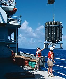 NOAA's Ocean Exploration scientists launch the CTD (conductivity, temperature, depth) over the side of the research vessel Thompson to take ocean measurements. |
Rebuilt Fish Stocks: As a result of the Department’s efforts to conserve and manage the nation’s fishery resources, one formerly overfished fish stock, Pacific Whiting, was fully rebuilt. Pacific Whiting was rebuilt in only two years. In addition, six stocks are no longer considered to be overfished, and overfishing has been eliminated on three stocks. Overfished and/or overfishing determinations were made for 20 stocks whose status was previously unknown. The percentage of stocks with a known population status that are not overfished increased from 64 percent to 72 percent, while the percentage of stocks with a known fishing rate that are not subject to overfishing increased from 79 percent to 81 percent.
NOAA, the U.S. Coast Guard, State of Florida, Monroe County, and Local Response Organizations Conducted a Successful “Safe Sanctuary” Exercise: The scenario involved the grounding of an 800 foot containership carrying 1,200,000 gallons of fuel in the Florida Keys National Marine Sanctuary. The ship injured ecological and historical/cultural resources and had two releases of oil and potentially unstable cargo. The exercise evaluated the collective ability to deliver data, real-time observations, forecasts, and scientific expertise and assets to address protection of NOAA trust resources in the event of a major incident.
NOAA Exploration of South Pacific Finds New Species and Magical Scenes; Sets Records for NOAA Undersea Research and Ocean Exploration: Hawaii Undersea Research Laboratory (HURL) and Ocean Exploration completed the longest and most-challenging ocean expedition in HURL’s 25-year history. The ship traveled 10,000 nautical miles and the Pisces submersibles made 67 dives, one as deep as 1,820 meters on Brothers undersea volcano. The results included discovery and the advancement of knowledge about the largely unknown ocean in that region. The nearly five month long international expedition to explore the South Pacific produced many discoveries, including numerous suspected new species, new ranges for known species, measurements of the diversity of marine life, and more data about undersea volcanoes and the rare interface of life based on sunlight with chemosynthetic organisms.
NOAA Finalized Regulations for the North Pacific Crab Rationalization Program: This new program allocates Bering Sea and Aleutian Islands king and Tanner crab fisheries resources not only to fishermen, but also to processors and communities. The program encourages crab harvesting cooperatives that can fish individual fishing quota collectively and cooperatively. The value of Bering Sea and Aleutian Islands crab is expected to increase under the program. Other rationalization programs, such as the American Fisheries Act pollock cooperatives and the halibut/sablefish individual fishing quota program, have resulted in more valuable, better managed, and safer North Pacific fisheries.
 NOAA continued its observer coverage in 42 fisheries in FY 2005, monitoring nearly 63,000 fishing days, up from 45,000 in 2000. |
NOAA Aids Regional Collaboration, Integration, and Research in Restoring the Great Lakes: The Department of Commerce and NOAA partnered with federal, state, and local governments, tribes, and others in the Great Lakes Interagency Task Force. Using science-based restoration, NOAA directed the Task Force’s efforts to the most important sources of problems and ensured evaluation of socioeconomic consequences of the restoration. In addition, NOAA’s Great Lakes Environmental Research Laboratory (GLERL), in collaboration with researchers in the United States and Canada, is leading one of the largest, most comprehensive Lake Erie research field programs. The two-year project, entitled International Field Years on Lake Erie (IFYLE) and initiated in May 2005, includes a series of ship cruises and field and laboratory work. Fourteen observation moorings will be deployed in the lake to continuously collect data. GLERL also conducted experiments on natural phytoplankton communities from the area that suggest genetic factors, not environmental, may be dominant in controlling “in situ” microcystin concentrations (a type of toxin).
Implementing the President’s Preserve America Initiative: Through an Executive Order, Preserve America, President Bush asked federal agencies to accelerate efforts to inventory, preserve, and showcase federally-managed historic and cultural resources and foster tourism in partnership with local communities. NOAA’s wealth of heritage resources includes centuries-old maps, charts, photographs, books, and scientific instruments recalling NOAA’s long and proud history and dedicated service. NOAA initiated the first annual NOAA Heritage Week, including an exhibit of heritage resources called the Treasures of NOAA’s Ark. The NOAA Preserve America Initiative Grant Program stimulated efforts within NOAA to preserve, protect, and promote heritage resources.
NOAA Worked with Various Government Agency Partners to Advance Marine Mammal Protection Act Reauthorization, The National Offshore Aquaculture Act, and Magnuson-Stevens Fisheries Conservation and Management Act Reauthorization: NOAA transmitted to Congress a comprehensive package of amendments to reauthorize the Magnuson-Stevens Act and the Marine Mammal Protection Act, and proposed the National Offshore Aquaculture Act. The bills meet Administration commitments made in the December 2004 U.S. Ocean Action Plan and other key objectives and necessary improvements.
NOAA Sea Grant Researchers Develop Means to Predict Risk of Dioxin in Fish: University of Washington Sea Grant scientists are revealing the intricate molecular mechanisms by which dioxin (and similar compounds like PCBs) derails normal processes in the cells of developing fish. With a detailed understanding of these mechanisms, toxicologists will have a way to predict the danger a given species faces from dioxin by conducting a relatively simple analysis of that species’ cellular biochemistry and describing how dioxin will corrupt it.
A listing of program evaluations that have been conducted follows.
FSD-15989-4-0001: Improvements Needed in the Reporting for NOAA GOALS–Build Sustainable Fisheries, Recover Protected Species, and Predict Climate Changes (four recommendations–Final Report)
This audit concluded that NOAA has unclear measures, weak procedures in place to ensure data reliability, insufficient documentation, and inadequate explanations. The recommendations were implemented according to the action plan and a follow-up audit was initiated in FY 2005 to gauge the adequacy of the Agency’s corrective actions.
STL-17242-5-0001: National Marine Fisheries Service (NMFS) Review Process for California Central Valley and State Water Projects’ Biological Opinion Deviated from Normal Practice (three recommendations–Final Report)
This report revealed inconsistencies between the way the consultation was initiated by the NMFS southwest regional office and the way it initiated other consultations. The report also found that that regional office did not comply with two controls in its normal review process. NMFS is implementing the recommendations.
GAO-05-240: Storm Water Pollution: Information Needed on the Implications of Permitting Oil and Gas Construction Activities (no recommendations)
This report concluded that substantially more oil and gas activities would likely be affected by Phase II of the stormwater rule than were affected in the Phase I rule for sites greater than five acres (in the past 12 months 433 oil and gas sites were permitted under the Phase I rule in Louisiana, Texas, and Oklahoma). NMFS participated in the review because Phase II of the stormwater rule is expected to substantially increase NMFS’ workload on consultations conducted pursuant to section 7 of the ESA, likely exceeding current staff capabilities.
GAO-05-241: Individual Fishing Quotas: Management Costs Varied and Were Not Recovered as Required (Part 3 IFQ Study) (two recommendations)
This report found that recovery of IFQ costs, as mandated in the Magnuson-Stevens Act, has been implemented in the Halibut and Sablefish IFQ, but not in the two East Coast IFQ programs, and recommended that the Agency implement cost recovery in all IFQ programs and develop the necessary guidance. NMFS generally agreed with the GAO recommendations and stated that the Agency will work with the Councils on IFQ cost recovery and will develop guidance on the determination of recoverable costs.
GAO-05-283: Klamath River Basin: Reclamation Met Its Water Bank Obligations, But Information to Stakeholders Could Be Improved (no recommendations)
This report examined compliance with the water bank requirements in the Biological Opinion on the Klamath River Basin project. GAO concluded the Bureau of Reclamation implemented the water bank in conformance with the Biological Opinion.
GAO-05-213: Food Safety: Federal Agencies Should Pursue Opportunities to Reduce Overlap and Better Leverage Resources (three recommendations)
This report identified overlaps in food safety activities at the U.S. Department of Agriculture (USDA), U.S. Food and Drug Administration (FDA), EPA, and NMFS and analyzed the extent to which the agencies use interagency agreements to leverage resources. GAO concluded that FDA and NMFS are not implementing an agreement designed to enable each agency to discharge its seafood responsibilities effectively. The report recommends that FDA and NMFS identify and inventory all active interagency food safety-related agreements and evaluate the need for these agreements, and where necessary, update the agreements to reflect recent legislative changes, new technological advances, and current needs. NMFS concurred with all recommendations and has submitted a draft revision of the subject agreement to FDA for their review and comment.
| Rating | Results |
|---|---|
| On Target | 5 |
| Slightly Below Target | 0 |
| Below Target | 0 |
| See Appendix A: Performance and Resource Tables for individual reported results. | |
Some highlights from this performance goal in FY 2005 include:
NOAA’s Height Modernization Project increases Gulf Coast Safety and Planning: NOAA invested more than $3.7 million in 2005 grant funding to implement the Height Modernization Project in the Gulf States. Implementation includes building the infrastructure and capacity of the states to determine and deliver consistent, accurate, and timely height information. The data are critical to determining effective highway evacuation routes, storm surge modeling, flood plain mapping, sea level rise calculations, vessel under-keel and bridge clearance, subsidence monitoring, and restoration of coastal habitats. NOAA released Technical Report 50 to describe the methods and results of research into recent rates of subsidence on benchmarks in the lower Mississippi Valley and northern Gulf Coast region. The data in this report were obtained from the analysis of leveling projects in NOAA’s geodetic database observed between 1920 and 1995.
NOAA Develops the Iraqi Geospatial Reference System (IGRS): NOAA provided critical assistance in the design, development, and implementation of IGRS. The IGRS was modeled after the National Spatial Reference System (NSRS) in the United States, which is managed by NOAA. Six Iraqi Continuously Operating Reference Stations (CORS) are now fully operational and data collection has been completed for a High Accuracy Reference Network (HARN) in southern Iraq. Army, Air Force, Marine, and civilian surveyors from many nations and disciplines are beginning to use the CORS and HARN stations for projects all around Iraq. The extreme accuracy and efficiency of the IGRS products are positively influencing the wide success of both military operations and civil reconstruction efforts.
NOAA’s Aviation Weather Program Exceeded Aggressive Performance Criteria for Aviation Forecasts: This progam is vital to aviation operations by improving the ceiling and visibility. The False Alarm Rate decreased five percentage points compared to FY 2004. The program also fielded and tested 25 Water Vapor Sensors to increase observations used in forecasts, created and conducted a new training course for meteorologists and pilot weather modules utilized by over 10,000 individuals, and successfully demonstrated the Volcanic Ash Collaboration Tool in collaboration with FAA.
New Physical Oceanographic Real-Time System (PORTS®) Established in Lower Columbia River: In partnership with the Port of Portland, NOAA established the Lower Columbia River PORTS® as the 13th PORTS®. The PORTS® program is designed to support safe, cost efficient marine transportation by providing accurate real-time oceanographic and meteorological data in a variety of user friendly formats, including telephone voice response and the Internet. Data are quality controlled on a 24/7 basis to allow navigation decisions to be made with confidence. The Columbia River annually handles nearly 48 million tons of cargo. Vessel operators must know the depth of the water in order to move the greatest amount of cargo without running the ship aground. In port areas, water levels and currents frequently differ from predictions as a result of changes in winds and water run off. Users of NOAA PORTS® information include port authorities, vessel pilots, shipping companies, U.S. Coast Guard, U.S. Navy, recreational boaters, fishermen, coastal managers, environmental organizations, academia, and surfers.
Consistent with the U.S. Ocean Action Plan and U.S. Commission on Ocean Policy Report, NOAA has adopted an ecosystem approach to management that will evolve over time in collaboration with its partners. The six strategies contained in the five year NOAA strategic plan include:
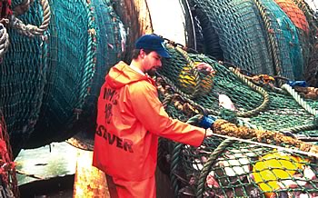
 Working with shrimp and longline fishermen, NOAA scientists have developed a new, soft Turtle Excluder Device (TED) and a highly effective double-flap hard TED that the shrimp industry has adopted to reduce the incidental capture of endangered and threatened sea turtles. |
NOAA is implementing the call by its stakeholders to move towards an ecosystem approach to managing uses of coastal and marine resources. NOAA is integrating the application of its multiple ecosystem mandates in partnership with universities; industry; non-governmental organizations; and local, state, and federal agencies by developing and implementing ecosystem approaches to management of coastal and marine resources. NOAA is seeking improved understanding of ecosystems, identification of regional ecosystems, development of ecosystem health indicators, and new methods of governance to establish the necessary knowledge, tools, and capabilities to fully implement ecosystem approaches to managing coastal, ocean, and Great Lakes resources. Advancement in NOAA’s performance measurement for an ecosystem approach to management is underway for FY 2006.
NOAA helps transportation information users and stakeholders reach their goals with the following strategies identified in the five year NOAA strategic plan:
In the future, NOAA plans to enhance the intermodal transportation network by improving available products and services and investing in transportation related observing systems. For example, NOAA will continue to build and maintain its suite of ENCs to supply commercial and recreational mariners with the digital navigation data they need to navigate safely in the 21st century. Additionally, NOAA will focus on equipping all 175 National Water Level Observation Network Stations with real-time operational capability at the top 150 U.S. seaports. Enhanced ice forecasts and refinements to aviation, marine, and surface weather predictions will also contribute to NOAA’s role in saving lives, property, and critical infrastructure. NOAA will continue to survey and chart U.S. waters, maintain the highly accurate positioning infrastructure the nation relies on each day, support Satellite Search and Rescue incidents, respond to hazardous material events, and support U.S. national interests in commercial remote sensing licensing. It is through these and other important activities that NOAA strives to improve and deliver information crucial to safe and efficient transportation.
The Department must further the examination of land-water interfaces from an ecosystem perspective to successfully address ocean and coastal issues. Human health linkages with weather, climate, and ecosystem goals are priorities that directly impact the U.S. economy. NOAA’s Strategic Plan’s emphasis on the nation’s needs for expanded commerce and economic development that is safe and environmentally sound directly supports the Department’s focus on a healthy and growing economy. One initiative especially highlights NOAA’s ability to provide services that support environmentally sound economic development. The Port Infrastructure and Economic Revitalization (PIER) initiative relies on partnerships to facilitate the revitalization of working waterfronts and other port infrastructure development needed to maintain pace with the exponential growth of the marine transportation system.
The Department’s response to addressing the transportation challenges facing the nation include building on the foundation of expertise, research, and technology development to deliver the information, tools, and services essential to safe, efficient, and environmentally sound transport on water, land, and in the air. Impacts to the system, particularly at vulnerable choke points, affect transit time, delivery reliability, efficiency, cost of goods transported, and the environment. To improve service delivery, NOAA consults with its stake holders to identify valid user needs that cannot be met with existing information; enhance products that support transportation systems; work with partners to conduct research and development in weather, modeling, and geopositioning; and improve the translation of research into operational value. NOAA must also focus on connecting and strengthening its observations systems that gather data for transportation information.
 NOAA surveys 95,000 nautical miles of U.S. coastline to provide an accurate and official delineation of the national shoreline for nautical chart production and coastal resource management. |