Strategic Objective 3.1
Advance understanding and predict changes in the Earth’s environment to meet America’s economic, social, and environmental needs
The Department’s role in understanding, observing, forecasting, and warning of weather events is expanding. The Department is strategically positioned to conduct sound, scientific research and provide integrated observations, predictions, and advice for decisionmakers who manage environmental resources, ranging from fresh water supplies to coastal ecosystems to air quality. Realizing that the Department’s information and services bridge both weather and climate timescales, the Department will continue to collect and analyze environmental data and issue forecasts and warnings that help protect life and property and enhance the U.S. economy. Commerce is committed to excellent customer service and depends on its partners in the private sector, academia, and government to add value and help disseminate critical weather and climate information. Commerce will expand services to support evolving national needs, including those associated with space weather, freshwater and coastal ecosystems, and air quality prediction.
Performance Goal: Serve society’s needs for weather and water information (NOAA)
|
|||||||||||||||||||||||||||||||||||||||||||||||||||||||||||||||||
| Rating | Results |
|---|---|
| On Target | 8 |
| Slightly Below Target | 1 |
| Below Target | 0 |
| See Appendix A: Performance and Resource Tables for individual reported results. | |
In FY 2005 NOAA continued its leadership in weather and water science and technology by expanding sources of observational data, advancing numerical models, and improving the accuracy of its forecasts and warnings. In addition, NOAA responded to society’s evolving needs for forecast services by leveraging its partnerships in the public, private, and academic sector.
Some highlights from FY 2005 include:
NOAA Begins Expansion of U.S. Tsunami Warning Program; Accurately Predicts West Coast Tsunami: In response to the December 26, 2004 Indian Ocean tsunami, NOAA has taken actions to expand the U.S. Tsunami Warning Program. The multi-year implementation plan, developed after NOAA received supplemental funding in FY 2005, will improve the Tsunami Warning and Mitigation System and Tsunami Forecast System. Among the steps taken in FY 2005, NOAA now provides 24 hours a day, seven days a week (24/7) operations at NOAA Tsunami Warning Centers, seismic monitoring, and improved community preparedness through the Tsunami Ready program. NOAA also utilized the experimental Tsunami Forecast System to accurately predict a tsunami just off the coast of Oregon following an approximately 7.2 magnitude earthquake off of the northern California coast in June. The accurate forecast and measurement of the resulting tsunami enabled NOAA’s Alaska Tsunami Warning Center to cancel its warning for the Oregon coast, which was issued five minutes after the earthquake struck.
National Digital Forecast Database (NDFD) Adds Additional Forecast Elements and Expands: Two new experimental elements, relative humidity and apparent temperature, were added to the NDFD for the lower 48 states, Puerto Rico, Hawaii, and Guam the week of June 20, 2005. This is the first expansion of NDFD. The elements were added in response to land management, emergency response, and public health officials who requested relative humidity, wind chill, and heat indices be added to the digital database. The National Weather Service (NWS) also upgraded six experimental elements to operational status for Puerto Rico and Hawaii in June. These six forecast elements are already operational for the lower 48 states and will be operational for Guam later in 2005. NOAA customers continue to be excited about these products and are utilizing the NDFD in decision-making and as part of business operations.
NOAA Deploys Seven New Hurricane Buoys: Following the active 2004 Atlantic hurricane season, the NOAA National Data Buoy Center, part of NWS, received $1.8 million in supplemental funding from Congress for the new buoy stations. NOAA launched six new weather data buoy stations (and re-established a seventh) designed to help the Tropical Prediction Center/National Hurricane Center (NHC) more accurately determine formation or dissipation, extent of wind circulation, maximum intensity, and center location of the tropical cyclones.
Improving Understanding and Prediction of Hurricane Intensity Change: NOAA began the Intensity Forecasting Experiment (IFEX), a multi-year project. IFEX is intended to improve NOAA’s understanding and prediction of hurricane intensity change by collecting observations that will aid in the improvement of current operational models and the development of the next-generation operational hurricane model, the Hurricane Weather Research and Forecasting model (HWRF). NOAA aircraft will be flown into hurricanes to take observations at different stages in their lifecycle, from formation and early organization to peak intensity and subsequent landfall or decay over open water.
NOAA’s Central Computer System (CCS) Runs with Full Backup: NOAA’s National Centers for Environmental Prediction (NCEP) computer operations were moved to the new Weather and Climate supercomputer. The planned system upgrade to the computer, under the $180 million nine-year contract, provides the necessary computational power to operate higher resolution numerical weather prediction models, coupled ocean-atmosphere models, operational climate models, and improved ensemble models. The new CCS, for the first time, is comprised of two identical, geographically separate systems, which will provide full backup capability for the entire suite of over five million numerical guidance products.
Observing Monsoons to Improve Predictions: NOAA successfully completed the North American Monsoon Experiment (NAME) field campaign in collaboration with other U.S., Mexican, and Central American agencies and academic institutions. NAME provides an unprecedented collection of detailed atmospheric, oceanic, and land-surface observations in the core region of the North American Monsoon over northwest Mexico, southwest United States, and adjacent oceanic regions. It better documents the evolution of the monsoon convection and precipitation and helps to outline the key physical processes that must be parameterized for improved simulations and predictions with climate models.
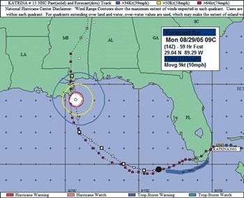 Within 48 hours of landfall on the central Gulf coast, all NOAA National Hurricane Center forecasts indicated that Katrina would come ashore in southeastern Louisiana with a hurricane intensity of at least a level 4. NOAA accurately predicted the path of this hurricane well in advance of landfall, enabling governments to initiate mass evacuations. |
NOAA and the Environmental Protection Agency (EPA) Extend Reach of Air Quality Forecasts and Promote Awareness: Air quality forecasts produced by NOAA and EPA were enhanced and expanded to serve better more regions of the United States. Forecast information for ground-level ozone that has been available for the northeastern United States will now include areas from just east of the Rocky Mountains to the Atlantic and Gulf coasts. Hour-by-hour forecasts, through midnight the following day, are available online, providing information for the onset, severity, and duration of poor air quality to more than 180 million people. State and local air quality forecasters use this information as another tool in issuing next-day alerts for poor air quality to more than 300 communities. Also in 2005, NOAA and the EPA urged Americans to “Be Air Aware” through an air quality awareness days campaign.
Researchers Demonstrate Radar Helps NOAA’s NWS Forecasters Save Lives: The June 5 issue of Weather and Forecasting, a journal of the American Meteorological Society (AMS), was published which included a study concluding that tornado warnings have improved significantly since NOAA’s NWS installed a network of Doppler weather radars a decade ago. Researchers examined the impact of Weather Surveillance Radar-1988 Doppler (WSR-88D), also known as NEXRAD, which was installed in the 1990s during the NWS’s $4.5 billion modernization. They also found the warnings from the radars have lowered the number of tornado casualties nationwide. This provided indirect evidence of the life-saving effects of tornado warnings.
NOAA Debuts New Heat/Health Watch Warning System in the Seattle Area: Seattle, WA, implemented a new Heat/Health Watch Warning System in the Spring of 2005, joining 14 other metropolitan areas using the Heat/Health Watch Warning System as guidance for issuing Excessive Heat Watches, Excessive Heat Warnings, and Heat Advisories. When unseasonably hot conditions do arise, the Seattle NWS office will issue a Heat/Health Watch Warning System message, alerting people in the region that precautions need to be taken against the hot weather. Based on NOAA NWS data from 1994 to 2003, excessive heat is the top weather-related killer.
GAO-05-253: Freshwater Programs: Federal Agencies’ Funding in the United States and Abroad (Final Report March 2005 - no recommendations for NOAA) http://www.gao.gov/new.items/d05253.pdf
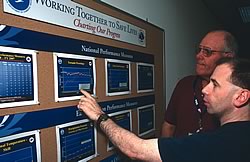 Blacksburg, Virginia, Warning Coordination Meteorologist Mike Emlaw, right, explains NWS performance goals to Pulaski County, Virginia, Emergency Manager Stan Crigger. All NWS office display the agency’s performance measures similarly. |
GAO conducted a review to determine for FYs 2000 through 2004 how much financial support federal agencies provided for freshwater programs in the United States and abroad. This review involved 32 agencies including NOAA. NWS provided the largest portion of the Agency’s budget for freshwater programs. The hydrology program supports watershed management and flood control activities, such as forecasting water availability on rivers, lakes, and streams and inland water research.
GAO-05-927: Managing for Results: Enhancing Agency Use of Performance Information for Management Decision Making http://www.gao.gov/cgi-bin/getrpt?GAO-05-927
NWS participated in a GAO study of how federal agencies use performance information and how selected federal agencies have used performance information to manage for results and what practices have contributed to their use of that information. Performance information can be used to trigger corrective action (e.g., change an existing program approach or adopt a new one), identify and disseminate successful practices, set job expectations for staff, and plan and budget. A final report was issued in September 2005 using NWS as an example for successful and effective use of performance measures.
IPE-17259: The Northeast River Forecast Center Is Well Managed, But Some Improvement Are Needed (eight recommendations – Final Report) http://www.oig.doc.gov/oig/reports/audit_inspection_and_evaluation_reports/index.html
This review concluded that financial and administrative operations are generally well managed, and management and oversight are adequate. OIG found the use of Geographic Information System should be expanded and NWS should be prepared to meet increased hydrology products demands and better document its plan for improving river forecast verification. While external partners are mostly satisfied, OIG found that some additional Weather Forecast Office and River Forecast Center coordination would be beneficial. OIG also touched on facility maintenance problems that need to be addressed. NOAA concurred with all recommendations, and a final action plan is being drafted.
| Rating | Results |
|---|---|
| On Target | 5 |
| Slightly Below Target | 0 |
| Below Target | 0 |
| See Appendix A: Performance and Resource Tables for individual reported results. | |
Society exists in a highly variable climate system, with conditions changing over the span of seasons, years, decades, or even longer. Seasonal and interannual variations in climate, like El Niño, led to economic impacts on the order of $25 billion for 1997-98, with property losses of over $2.5 billion and crop losses approaching $2.0 billion. Given such stresses as population growth, drought, and increasing demand for fresh water it is essential for NOAA to provide reliable observations, forecasts, and assessments of climate, water, and ecosystems to enhance decisionmakers’ ability to minimize climate risks. This information supports decisions regarding community planning, business management, and natural resource and water planning. In the U.S. agricultural sector alone, better forecasts can be worth more than $300 million in avoided losses annually.
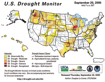 The week of September 20th, 2005 Drought Monitor, jointly produced by NOAA, USDA, and the University of Nebraska. |
In FY 2005 NOAA continued its efforts to obtain the best science through the Climate Change Science Program (CCSP) and NOAA Climate Program. NOAA accomplished this through its continuing role as lead agency of the interagency CCSP. In addition, NOAA increased the production of climate information and services for decisions, including Synthesis and Assessment Reports, implementation of the National Integrated Drought Information System (NIDIS), and completion of initial climate scenario runs for the Intergovernmental Panel on Climate Change (IPCC).
NOAA Assists the IPCC Fourth Assessment Report on Climate Change: NOAA’s new state-of-the-art coupled climate model (CM2) provided massive amounts of data to the world’s research communities for the IPCC Fourth Assessment Report on Climate Change (2007). The CM2 model was evaluated and revealed as one of the best in the world by a variety of measures. This accomplishment represents the culmination of an intensive effort by the Geophysical Fluid Dynamic Laboratory (GFDL) scientists over the last several years to construct this climate model. The experiment was begun using two initial conditions: one representing present-day climate, and one from 1860. To assess the effects of global warming, two scenarios were created; the first ran increasing atmospheric carbon dioxide (CO2) concentrations one percent per year until it reached twice the concentration relative to present day and the second was run increasing atmospheric concentrations of CO2 one percent per year until it reached four times the concentration relative to present day. Nearly 500 gigabytes of data have been shipped to the Program for Climate Model Diagnosis and Intercomparison (PCMDI) on a large computer disk. NOAA/GFDL is the first organization to ship nearly 500 gigabytes of model data from a state-of-the-art model.
Kuroshio Extension Observatory Buoy has Stunning First Year: Outstanding buoy performance drives improved ocean models that underpin NOAA’s understanding of the role of the oceans in climate. The moored buoy located in the Kuroshio current in the north Pacific returned 100 percent of surface data, including winds, air temperature, relative humidity, rain rate, downwelling solar and longwave radiation, sea surface temperature, and salinity. It also returned 90 percent of subsurface temperature and salinity data. The mooring is located in international waters, where the currents can be strong and deep, winds high, and the sea state rough. The buoy survived the record 2004 typhoon season and a full season of winter storms, providing unprecedented data for analyzing air-sea interaction in the western boundary region of the north Pacific.
Presidential Award given to NOAA Research Scientist: Dr. Daniel Cziczo, currently a research scientist at the Institute for Atmospheric and Climate Science at the Swiss Federal Institute of Technology, and formerly a research scientist at NOAA’s Aeronomy Lab and Cooperative Institute for Research in Environmental Sciences, was awarded a 2004 Presidential Early Career Award for Scientists and Engineers. He was awarded the nation’s highest award for young scientists for pioneering research and leadership in climate studies that have made the first unambiguous identification of the atmospheric particle types that are effective seeds for cloud formation in the atmosphere.
NOAA Advances Global Ocean Observing System (GOOS) with Deployment of Global Drifter 1250: In cooperation with interagency and international partners, NOAA advanced the global component of the GOOS past the 50 percent milestone in February 2005. A major earth observation milestone was also achieved on September 18, 2005 when NOAA ceremonially deployed Global Drifter 1250 near Halifax, Nova Scotia. With this deployment, the global surface drifting buoy array achieved its design goal of 1250 data buoys in sustained service and became the first component of the GOOS to be fully implemented. This milestone also represented the first element of GEOSS to be completed.
AgClimate Decision Support Tool: NOAA-supported university scientists introduced AgClimate, a prototype decision support Web site (http://www.agclimate.org/) which includes several decision support tools. The current version of AgClimate includes (1) a tool which allows users to learn about risks associated with climate variability and El Niño/Southern Oscillation (ENSO) for their county; (2) crop risk tools for peanut, tomato, and potato to enable users from selected counties to learn how climate variability and ENSO affect these crops, as well as to view probabilities of how these crops will perform for a climate forecast; and (3) wildfire risk forecast for the forested areas of the Southeast.
Release of the Annual Greenhouse Gas Index (AGGI): NOAA developed and released for the first time this year its AGGI.. The AGGI is a readily understood measure of the status of long-lived, human-influenced greenhouse gases. The NOAA AGGI is designed to enhance the connection between scientists and society by providing a normalized standard that can be easily understood and followed. The contribution of long-lived greenhouse gases to climate forcing is well understood by scientists and has been reported by NOAA through a range of national and international assessments. Nevertheless, the language of scientists (for example, watts per square meter per year) often eludes policymakers, educators, and the general public. This index is designed to help bridge that gap.
NOAA Develops a Plan for a National Integrated Drought Information System (NIDIS) Implementation Office: NIDIS answers the call for a national drought policy that must provide for the development of a comprehensive monitoring system to collect, analyze and disseminate available data and products in a usable manner. Following the recommendation of the Western Governors’ Association, NOAA will host the NIDIS Implementation Office, which will manage and oversee the broad-based NIDIS Implementation Team (interagency, states, tribes, and other partners). A plan for the Office was completed this year.
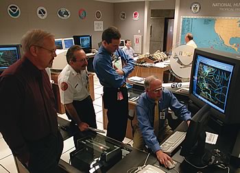 National Hurricane Center Director Max Mayfield previews Hurricane Michelle’s track for (from left) Jim Lushine, Warning Coordination Meteorologist, WFO, Miami; Chuck Lanza, Director, Emergency Management, Miami-Dade County; and an unidentified aide. |
The Department utilizes several strategies, identified in the five year NOAA strategic plan, to improve accuracy and timeliness of weather and water information. Improved weather and water information can have a profound impact on the economy. The Department strives to ensure that reliable, accurate, and timely weather and water information is available for informed and reasoned decision-making. Strategies to achieve this end state include:
One of NOAA’s top priorities is to effectively and efficiently deliver information and services to customers when they need it and in standardized formats. NOAA strives to support a safer, healthier, and economically stronger U.S. through reliable, timely, and accurate weather and water information. NOAA-wide information such as all-hazards warnings and a wide range of environmental information from an expanding customer base must be available in digital formats with the necessary supporting infrastructure.
NOAA will continue to provide critical services to the nation, including (1) advancing science to improve water resource forecasting and service delivery; (2) accelerating NOAA’s tsunami detection, warning and mitigation capabilities and expanding its scope from the Pacific to the Atlantic and Caribbean; (3) accelerating research to yield improvements in the accuracy of one-day to two-week high-impact weather forecasts; (4) improving international efforts to address medium range forecasting and climate variability; (5) accelerating the expansion of national ozone air quality forecasts; and (6) improving operational atmospheric, ocean, and coastal modeling capabilities.
NOAA must continue to refine its Earth observing architecture and data management infrastructure in order to increase its capacity to meet the information requirements of NOAA’s four mission goals. NOAA’s mission goals are directly related to the “nine societal benefit areas” identified by the intergovernmental GEO and the USGEO. As such, NOAA will continue to be an active participant on both the USGEO, which is charged with developing the U.S. Integrated Surface Observing System (ISOS), and the GEO, which is developing GEOSS.
The Department utilizes several strategies identified in the five year NOAA strategic plan to assist customers in better understanding the impacts of climate change and variability. Like weather, improved climate information can have a profound impact on the economy, and the Department strives to ensure that reliable, unbiased climate information is available for informed and reasoned decision-making. Strategies to achieve this end state include:
The Department’s Climate Program is aligned with the five goals of the CCSP in an effort to ensure optimal partnerships with other federal agencies and to advance the state of the science, while also enabling society to understand and respond to changing climate conditions. The program is working to improve the linkages among planning, budgeting, and performance management activities. The Climate Goal is also striving to develop more outcome- and impact-oriented performance measures representative of the diverse research, development, and operational activities conducted within the Department. As these efforts are realized, the Department’s performance measures will be adjusted to evolve with the needs of the program.
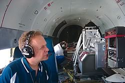 A NOAA scientist aboard a DC-3 aircraft studies a real-time display of ozone and aerosol data for the New England Air Quality Study. |
The 21st century poses complex challenges for the Department. As the new century unfolds, new priorities for NOAA action are emerging in the areas of climate change, freshwater supply, and ecosystem management. In recent years, extreme drought and flooding conditions in large regions of the nation have combined to make improved water resources prediction an urgent requirement for the Department’s future weather and climate mission. Human health linkages with weather, climate, and ecosystem goals are also priorities and directly relate to the Administration’s focus on a healthy and growing economy. In 2003, the U.S. government formed the CCSP to facilitate the creation and application of knowledge of Earth’s global environment through research, observations, decision support, and communication. The Department, working with 12 other federal agencies, leads this nationwide effort. In response to last year’s devastating Indian Ocean tsunami, a new tsunami detection and warning network is planned. This network will be an integral part of GEOSS and the United States will play a key role in this effort.
The climate, weather, and water challenges that face the nation continue to grow as trends such as just in-time production, globalization, and increased travel amplify the impact of climate, weather, and water information services on the economy. Substantial population and business growth in coastal and arid regions increases the sensitivity to climate, weather and water conditions as well. This interdependence means climate, weather, and water events in one geographic area can have national and international economic impact.