Most Important Results
|
|||||||||||||||||
| Status | Number of Measures |
|---|---|
| Blue: exceeded performance target | 3 |
| Green: met performance target | 20 |
| Yellow: almost met performance target | 4 |
| Red: did not meet performance target | 3 |
The Department achieved success in 77 percent of the targets that were set.
The devastation left in Katrina’s wake over southeast Louisiana and coastal Mississippi was immense. The storm surge ravaged coastal Mississippi, and several levee breaches occurred in and around New Orleans. The levee breaches and overtopping resulted in floodwaters of 15 to 20 feet covering about 80 percent of the city. The catastrophic damage and loss of life inflicted by this hurricane is staggering, with an estimated 1,353 direct fatalities and 275,000 homes damaged or destroyed. Total economic losses could be greater than $100 billion. These impacts make Katrina the costliest hurricane in U.S. history and one of the five deadliest hurricanes to ever strike the United States.
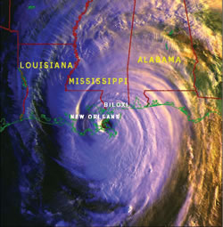 Satellite image of Hurricane Katrina passing over the Gulf Coast. |
A follow-up service assessment found that the National Weather Service (NWS) performed admirably, before, during, and after Katrina. The products and services provided by NWS offices were particularly accurate and timely, and they contributed significantly to critical customer decision-making. The hurricane forecast track error was considerably better than average through the five-day forecast period. Lead times on hurricane watches and warnings for Louisiana, Mississippi, Alabama, and the Florida panhandle were eight hours above average. A noteworthy moment for NWS came when the Weather Forecast Office (WFO) in New Orleans/Baton Rouge issued a statement one day prior to Katrina’s landfall that emphasized the likely impacts of the hurricane on southeast Louisiana and coastal Mississippi. Due to the unprecedented detail and foreboding nature of the language used, the statement helped reinforce the actions of emergency management officials as they coordinated one of the largest evacuations in U.S. history. The NWS actions leading up to Katrina’s landfall and the efforts of the NWS tropical cyclone outreach program over the last two decades contributed to these high evacuation rates and undoubtedly saved many lives.
During extremely difficult working conditions, the ingenuity, dedication, and sheer will of NWS employees enabled the provision of products and services even as infrastructure and backup systems failed. Incident meteorologists served a vital role in the aftermath of Katrina by establishing portable communications systems and weather observing systems to mitigate critical outages. Most importantly, service backup operations were transparent to most users and partners as high quality products and services were provided by alternate offices.
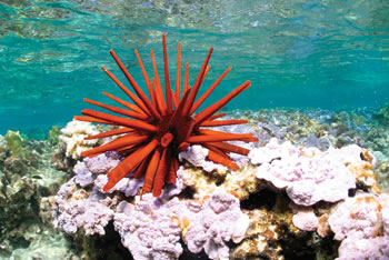 |
NOAA image of red pencil urchin found
among the more than 7,000 species in the new Northwestern Hawaiian
Islands Marine National Monument. |
“Along with the two national wildlife refuges already in the area, this national monument provides permanent protection and conservation for the extraordinary natural resources and wildlife of the Northwestern Hawaiian Islands. Relatively untouched by human activities, these isolated waters and coral reefs provide vital habitat for the endangered Hawaiian monk seal, the threatened Hawaiian green sea turtle and other rare marine species.” Dirk Kempthorne, |
|
The Administration created the world’s largest marine conservation area off the coast of the North Western Hawaiian Islands in order to permanently protect the area’s pristine coral reefs and unique marine species. The Northwestern Hawaiian Islands Marine National Monument encompasses nearly 140,000 square miles of U.S. waters, including 4,500 square miles of relatively undisturbed coral reef habitat that is home to more than 7,000 species. The monument will be managed by the Department of the Interior’s (DOI) U.S. Fish and Wildlife Service and the Department’s National Oceanic and Atmospheric Administration (NOAA), in close coordination with the State of Hawaii.
“This is a landmark achievement for conservation, protection and enhancement of the Northwestern Hawaiian Islands,” said Department Secretary Carlos Gutierrez. “Approximately one quarter of the species here are found nowhere else in the world and a marine national monument will provide comprehensive, permanent protection to this region.”
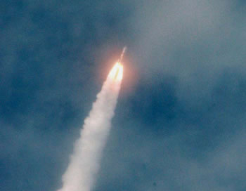 Image of NOAA GOES-13 satellite being launched from the Cape Canaveral Air Force Station in Florida aboard a Boeing Delta IV rocket trailing a plume of smoke as it roars through the thin cloud cover on its way to space. |
NOAA and the National Aeronautics and Space Administration (NASA) officials confirmed that a new geostationary operational environmental satellite, designed to track hurricanes and other severe weather impacting the nation, successfully reached orbit. The first signal acquisition occurred six hours and 30 minutes after the launch, at the Air Force Tracking Station, Diego Garcia, located in the Indian Ocean.
The NOAA satellite, GOES-13, will supply data critical for fast, accurate forecasts and warnings for severe weather, including tornadoes, winter storms, and hurricanes (after a period of on-orbit storage). Additionally, it will detect solar storm activity, relay distress signals from emergency beacons, monitor the oceans, and scan the landscape for the latest drought and flood conditions.
This satellite will serve the nation by monitoring conditions that trigger dangerous weather, and it will serve the world by contributing vast amounts of observational data, as part of its contribution to the Global Earth Observation System of Systems (GEOSS).
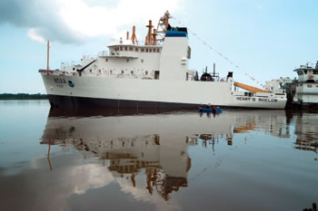 The NOAA ship HENRY B. BIGELOW after being launched at the VT Halter Marine Inc., shipyard in Moss Point, MS. |
NOAA took delivery of HENRY B. BIGELOW, one of a new class of FSVs being built under contract with VT Halter Marine Inc., in Pascagoula, MS. The vessel will support NOAA research efforts in conservation and management of fisheries and marine ecosystems primarily in northeastern U.S. waters, replacing the 45-year-old ALBATROSS IV. The ship will be home ported in New England, although a permanent base has not been named. The ship will be based temporarily at Naval Station Newport, in Newport, RI.
Like its sister ship OSCAR DYSON, BIGELOW’s high-tech capabilities make it one of the most advanced fisheries research ships in the world. The advanced capabilities of HENRY B. BIGELOW will enable NOAA to conduct its fisheries research and assessment mission in New England with greater accuracy and cost efficiency.
Senator Gregg stated, “The HENRY B. BIGELOW is going to have a tremendous impact on the way scientists and researchers study the health of our marine environment, especially in the Gulf of Maine and the northeast. And it is a fitting tribute to the kids from Winnacunnet that this vessel, bearing the name they chose to honor one of the most respected oceanographers in the northeast, is now going to be used off our shores.”
HENRY B. BIGELOW is the second of four 208-foot FSVs to be delivered by VT Halter Marine, with the third ship, PISCES, and the as-yet unnamed fourth ship in various stages of construction. Together, these ships will expand the capabilities of the NOAA fleet greatly by meeting data collection requirements of the National Marine Fisheries Service (NMFS), as well as providing a cutting-edge, low acoustic signature. The FSV will have the ability to perform hydro-acoustic surveys of fish, and also will be able to conduct bottom and mid-water trawls while running physical and biological-oceanographic sampling during a single deployment—a combined capability unavailable in the private sector.
Advancing understanding of climate variability, potential responses, and options: The Department continues its work to develop a predictive understanding of the global climate system. The Department will continue to target climate-sensitive sectors and the climate literate public and help them to more effectively incorporate the Department’s climate products into their everyday planning and decision-making processes. These efforts involve building integrated atmospheric and oceanic climate observing systems, including expansion of the global ocean observing system in support of the Integrated Ocean Observing System (IOOS)/Global Ocean Observing System, improving analyses and attribution of climate trends for improved models and forecasts, understanding the impacts of climate variability and change on marine ecosystems (e.g. fish stocks), and expanding regional decision support climate information and services to a variety of economic sectors (e.g. agriculture, energy providers).
Improving accuracy and timeliness of weather and water information: The Department will work to improve the accuracy and lead time of warnings all severe weather events. At the same time, it will work to improve the accuracy of predictions of daily weather patterns.
Advancing ecosystem approaches to management: The Department will promote smart development on the coasts, and the protection and restoration of marine and coastal habitats and biodiversity. With population expected to grow by five to eight percent in the next five years, the Department will guide coastal managers in balancing the benefits of economic growth with managing and mitigating the impacts of growth on coastal environments and helping to resolve increasing conflicts in competition for land and water resources.
Improving integration and accuracy of marine, aviation, and surface transportation information: A safe, efficient, and environmentally sound transportation network is crucial to the nation’s economic strength. The Department will work to provide accurate and timely weather information to promote the safe transport of goods. Transportation weather information supports the reduction of weather related crashes and incidents in the air, at sea, and on land.
Improving and expanding knowledge of the world’s oceans through deep-sea exploration: The ocean is the lifeblood of Earth, covering more than 70 percent of the planet’s surface, driving weather, regulating temperature, and ultimately supporting all living organisms. Throughout history, the ocean has been a vital source of sustenance, transport, commerce, growth, and inspiration. Yet, for all the reliance on the ocean, 95 percent of the ocean remains unexplored—unseen by human eyes. The Department explores the oceans for the purpose of discovery and advancement of knowledge; supporting missions to investi-gate and document unknown and poorly known areas of the ocean.
Revolutionizing understanding of how Earth works through the GEOSS: Sixty countries, the European Commission, and more than 40 international organizations are supporting the development of a GEOSS that, over the next decade, will revolutionize the understanding of Earth and how it works. With benefits as broad as the planet itself, the U.S.-led initiative promises to make people and economies around the globe healthier, safer, and better equipped to manage basic daily needs. The aim is to make 21st century technology as interrelated as the planet it observes, predicts, and protects, providing the science on which sound policy and decision-making must be built. The United States, led in major part by the Department, is spearheading such a system, domestically and around the world.